mail_outline sales@mediastorehouse.com
213 items
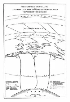
Old chromolithograph illustration of schematic representation of an attack on a modern fortressCopyright has expired on this artwork. From my own archives, digitally restored
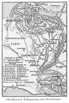
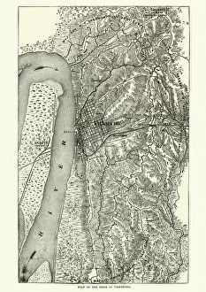
Old engraved map of the Siege of Sevastopol during the Crimean War, 1854 To 1855Copyright has expired on this artwork. From my own archives, digitally restored
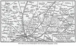
Old engraved map of Second Battle of Orleans, battle of the Franco-Prussian War of 1870Copyright has expired on this artwork. From my own archives, digitally restored
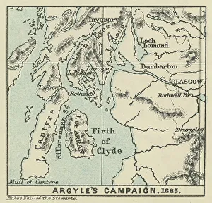
Old engraved map of Argyll's Rising, also known as Argyll's RebellionCopyright has expired on this artwork. From my own archives, digitally restored
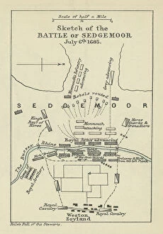
Old engraved map of Battle of the Sedgemoor (06. 07. 1685) - last and decisive engagement between the Kingdom ofCopyright has expired on this artwork. From my own archives, digitally restored
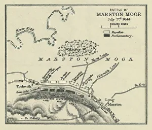
Old engraved map of Battle of Marston Moor (02. 07. 1644)Copyright has expired on this artwork. From my own archives, digitally restored
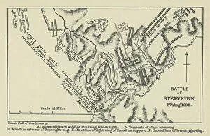
Old engraved map of Battle of Steinkirk, Steenkerke, Steenkirk or Steinkirk (03. 08. 1692) during the Nine Years WarCopyright has expired on this artwork. From my own archives, digitally restored
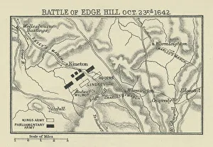
Old engraved map of Battle of Edge Hill (23. 10. 1642)Copyright has expired on this artwork. From my own archives, digitally restored. The Battle of Edgehill (or Edge Hill) was a pitched battle of the First English Civil War
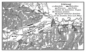
Old engraved map of the Battle of Saint Gotthard - part of the Austro-Turkish War (1663-1664)Copyright has expired on this artwork. From my own archives, digitally restored
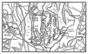
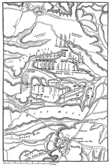
Old engraved map of Battle of Naseby (14. 06. 1645) - part of First English Civil WarCopyright has expired on this artwork. From my own archives, digitally restored. The Battle of Naseby took place on Saturday 14 June 1645 during the First English Civil War
Old engraved illustration of Battle of Zenta, also known as the Battle of Senta, was fought on 11 September 1697Copyright has expired on this artwork. From my own archives, digitally restored
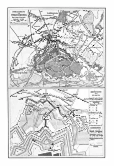
Old chromolithograph map of siege of Strasbourg, FranceCopyright has expired on this artwork. From my own archives, digitally restored
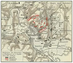
Old engraved map of Battle of Sedan, fought during the Franco-Prussian War from 1 to 2 September 1870Copyright has expired on this artwork. From my own archives, digitally restored
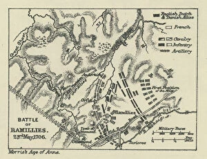
Old engraved map of Battle of Ramillies (23. 05. 1706) - battle of the War of the Spanish SuccessionCopyright has expired on this artwork. From my own archives, digitally restored
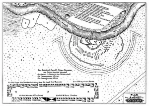
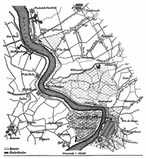
Old engraved map of the siege of Antwerp by Alexander Farnese from 10. 07. 1584 to 17. 08. 1585Copyright has expired on this artwork. From my own archives, digitally restored
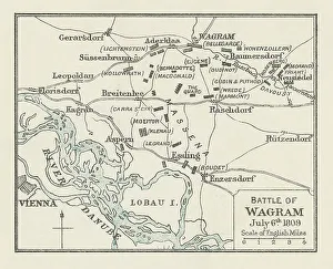
Old engraved map of Battle of Wagram (5 and 6 July 1809)Copyright has expired on this artwork. From my own archives, digitally restored
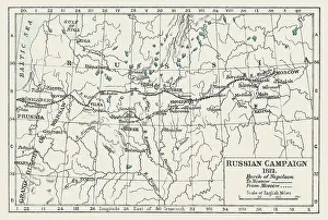
Old engraved illustration of Russian Campaign (1812), French occupation of Moscow, March of Napoleon to MoscowCopyright has expired on this artwork. From my own archives, digitally restored
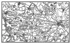
Old engraved map of the Battle of Kolin on 18 June 1757 saw 54, 000 Austrians under Count von Daun defeat 34Copyright has expired on this artwork. From my own archives, digitally restored
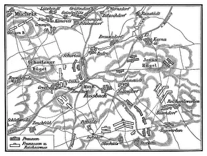
Old engraved map of Battle of Rossbach (5 November 1757 ) during the Third Silesian WarCopyright has expired on this artwork. From my own archives, digitally restored
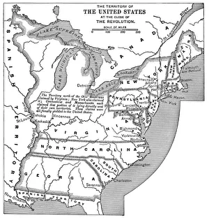
Old map of Territory of United States at the close of the RevolutionAntique Illustration. Copyright has expired on this artwork. From my own archives, digitally restored
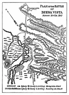
Engraved illustration, plan of the battle of Buena Vista (Morning 23. 02. 1847)Copyright has expired on this artwork. From my own archives, digitally restored. The Battle of Buena Vista, the Battle of La Angostura in Mexico, and sometimes as Battle of Buena Vista/La Angostura
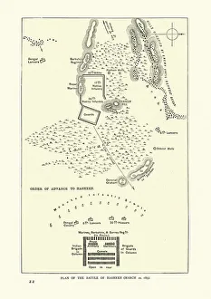
Plan of the Battle of Hasheen March 20th 1885, Mahdist WarVintage illustration of Plan of the Battle of Hasheen March 20th 1885, Mahdist War
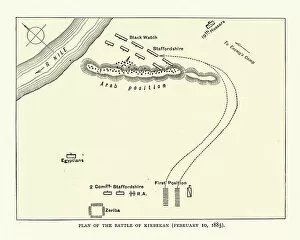
Plan of the Battle of Kirbekan February 10, 1885, Mahdist WarVintage illustration of Plan of the Battle of Kirbekan February 10, 1885, Mahdist War. The Battle of Kirbekan was a battle in the Mahdist War
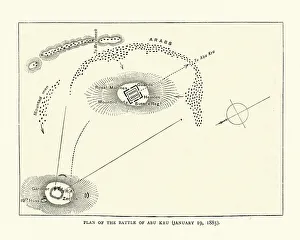
Plan of the Battle of Abu Kru, 1885, British Sudan campaignVintage illustration of Plan of the Battle of Abu Kru, 1885. The Battle of Abu Kru (also known as the Battle of Gubat) was part of the British Sudan campaign
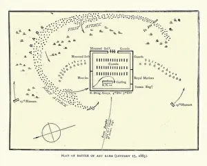
Plan of the Battle of Abu Klea, Mahdist war, 19th CenturyVintage illustration of Plan of the Battle of Abu Klea, Mahdist war, 19th Century. The Battle of Abu Klea, or the Battle of Abu Tulayh took place between the dates of 16 and 18 January 1885
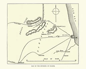
Map of the environs of Suakin, Sudan, Mahdist War, 19th CenturyVintage illustration of Map of the environs of Suakin, Sudan, 19th Century
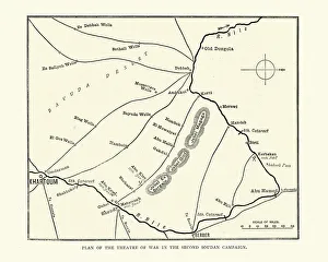
Plan of the theatre of war, Second sudan campaign, Mahdist War 19th CenturyVintage illustration of Plan of the theatre of war, Second sudan campaign, Mahdist War 19th Century
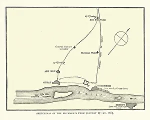
Map of the area arounf the Battle of Abu Klea, 1885Vintage illustration of Map of the area arounf the Battle of Abu Klea, 1885. The Battle of Abu Klea, or the Battle of Abu Tulayh took place between the dates of 16 and 18 January 1885, at Abu Klea
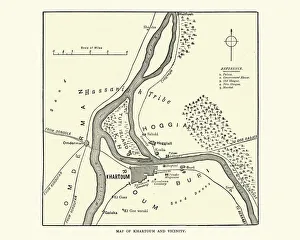
Map of Khartoum and vicinity at the time of siege of Khartoum 1884Vintage illustration of Map of Khartoum and vicinity at the time of siege of Khartoum 1884
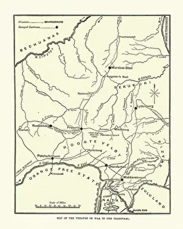
Map of the Transvaal during First Boer WarVintage illustration Map of the theatre of War in the Transvaal, First Boer War, 19th Century
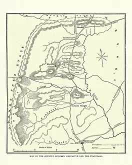
Map of the area between Newcastle and Transvaal South AfricaVintage illustration Map of the area between Newcastle and Transvaal South Africa, during the First Boar War, 19th Century
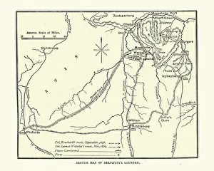
Map of Sekhukhune King of the Marota country, Southern AfricaVintage illustration Map of Sekhukhune King of the Marota country, Southern Africa, 19th Century
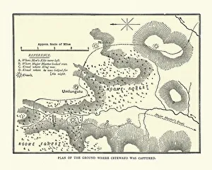
Plan of Ngome forest showing where Cetshwayo was capturedVintage illustration Plan of Ngome forest showing where Cetshwayo King of the Zulus was captured, 19th Century
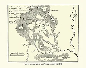
Plan of Battle of Laings Nek, First Boer WarVintage illustration Battle of Laings Nek, a major battle fought at Laings Nek during the First Boer War on 28 January 1881. 19th Century
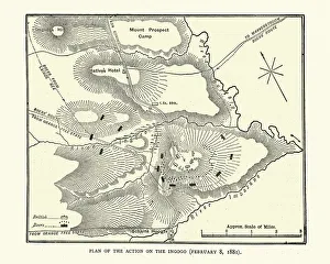
Plan of the Battle of Schuinshoogte (Ingogo), First Boer WarVintage illustration Plan of the Battle of Schuinshoogte (Ingogo), 19th Century. Which was fought north of Newcastle, KwaZulu-Natal, on 8 February 1881 during the First Boer War
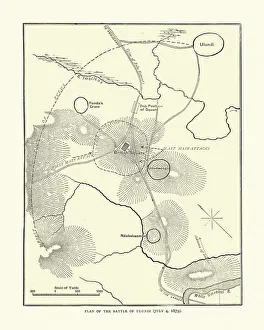
Plan of the Battle of Ulundi, 1879, Anglo-Zulu warVintage illustration Plan of the Battle of Ulundi, 1879, Anglo-Zulu war, 19th Century. The Battle of Ulundi took place at the Zulu capital of Ulundi on 4 July 1879
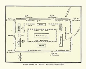
Plan of a British military square at Battle of UludiVintage illustration Plan of a British military square at Battle of Uludi, 19th Century. The Battle of Ulundi took place at the Zulu capital of Ulundi on 4 July 1879
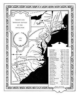
Twenty Five Important US Revolution Battles 1775 - 1783
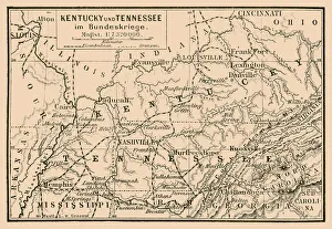
Kentucky and Tennessee in federal war mapIllustration of a Kentucky and Tennessee in federal war map
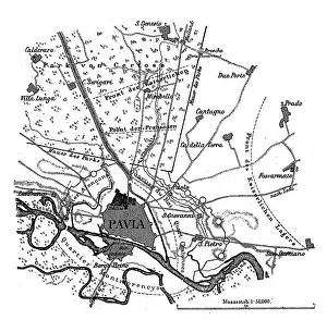
Plan of the Battle of PaviaIllustration of a Plan of the Battle of Pavia
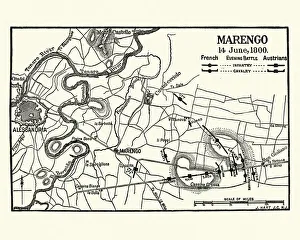
Map of Battle of Marengo, Evening 14 June1800Vintage engraving of Map of Battle of Marengo, Evening 14 June1800. The Battle of Marengo was fought on 14 June 1800 between French forces under Napoleon Bonaparte
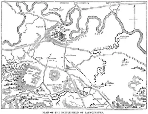
Battle of Bannockburn 1314Vintage engraving showing a plan of the Battle of Bannockburn. The Battle of Bannockburn (24 June 1314) was a significant Scottish victory in the Wars of Scottish Independence
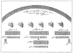
Battle of Lepanto" Vintage engraving from 1876 showing the plan of action from the Battle of Lepanto. The Battle of Lepanto took place on 7 October 1571 when a fleet of the Holy League
Plan of the Battle of NasebyIllustration of a Plan of the Battle of Naseby
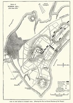
Plan of the Battle of Bunker Hill, 1775Vintage engraving of a Plan of the Battle of Bunker Hill, 1775. The Battle of Bunker Hill was fought on June 17, 1775, during the Siege of Boston in the early stages of the American Revolutionary War
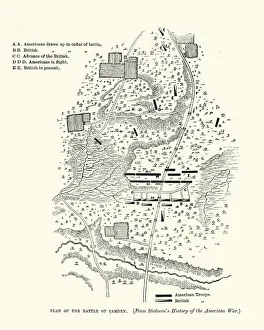
Plan of the Battle of Camden, American Revolutionary WarVintage engraving of a Plan of the Battle of Camden, American Revolutionary War. The Battle of Camden was a major victory for the British in the Southern theater of the American Revolutionary War
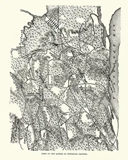
Plan of the Battle of Shiloh (Pittsburgh Landing)Vintage engraving of Plan of the Battle of Shiloh (Pittsburgh Landing). The Battle of Shiloh (also known as the Battle of Pittsburgh Landing)
Map of Siege of Vicksburg, American Civil WarVintage engraving of a plan of the Siege of Vicksburg the final major military action in the Vicksburg campaign of the American Civil War