mail_outline sales@mediastorehouse.com
213 items
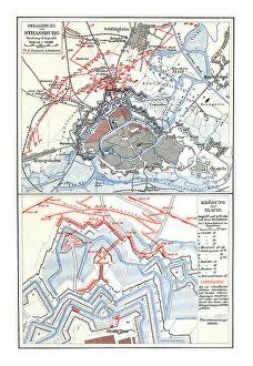
Old chromolithograph map of siege of Strasbourg, FranceCopyright has expired on this artwork. From my own archives, digitally restored
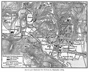
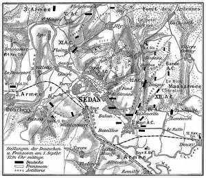
Old engraved map of Battle of Sedan, fought during the Franco-Prussian War from 1 to 2 September 1870Copyright has expired on this artwork. From my own archives, digitally restored
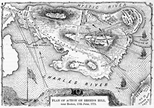
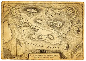
Plan of action at the Battle on Breeds Hill" Vintage engraving of the Plan of action at the Battle of Breeds Hill (also known as the Battle of Bunker Hill), Near Boston on 17th June 1775. Part of the American War of Independence"
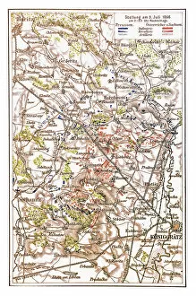
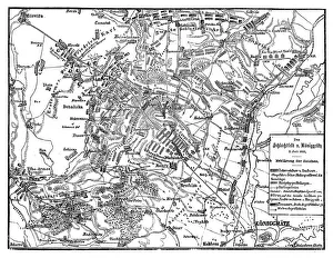
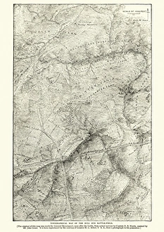
Plan of the battlefield of The Battle of KAoniggrAÔé¼tz, also known as the Battle of SadowaIllustration of a Plan of the battlefield of The Battle of Koniggratz, also known as the Battle of Sadowa, Sadova, or Hradec Kralove, was the decisive battle of the Austro-Prussian War
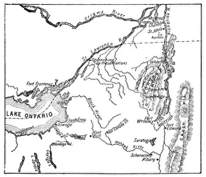
Antique Map of St. Lawrence Area during the War of 1812 - 19th CenturyVintage map showing early territorial borders and military positions in the St Lawrence area during the War of 1812. Vintage etching circa late 19th century
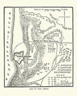
American Civil War, Map of Fort Henry, TennesseeVintage engraving of a scene from the American Civil War, Battle of Fort Henry, fought on February 6, 1862, in western Middle Tennessee, during the American Civil War
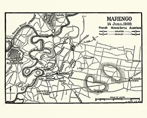
Map of Battle of Marengo, Morning 14 June1800Vintage engraving of Map of Battle of Marengo, Morning 14 June1800. The Battle of Marengo was fought on 14 June 1800 between French forces under Napoleon Bonaparte
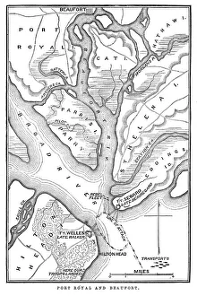
Battle of Port RoyalVintage engraving from 1863 of a map of the Battle of Port Royal which was one of the earliest amphibious operations of the American Civil War
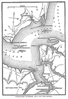
Fort Monroe and its environsVintage engraving from 1863 of a map of Fort Monroe and its environs. Fort Monroe played an important role in the American Civil War
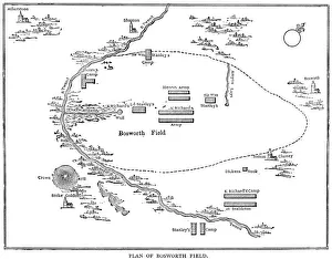
Battle of Bosworth FieldVintage engraving showing a plan of the Battle of Bosworth Field. The Battle of Bosworth (or Bosworth Field) was the last significant battle of the Wars of the Roses
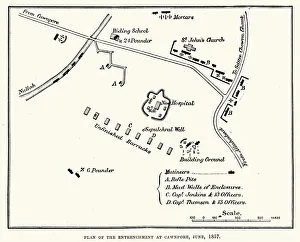
Plan of the Entrenchment at Cawnpore, June, 1857, during the Indian Rebellion of 1857
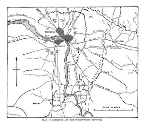
Plan of Richmond and the surrounding country
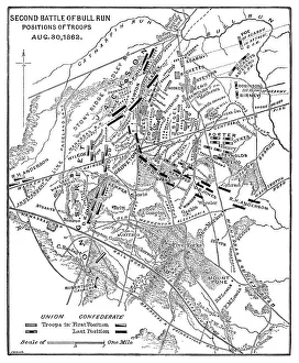
Map of the Second Battle of Bull Run - Scanned 1886 map
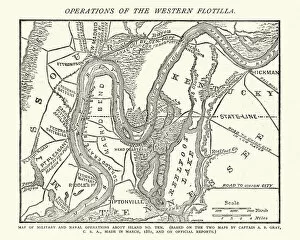
American Civil War, Map operations of the western flotillaVintage engraving of American Civil War, Map operations of the western flotilla
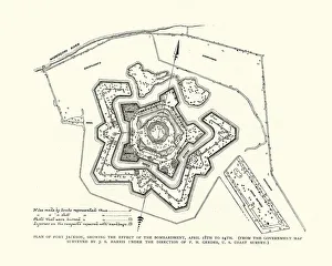
American Civil War, Fort Jackson, LouisianaVintage engraving of plan of Fort Jackson, Louisiana. Fort Jackson is an historic masonry fort located some 40 miles (64Akm) up river from the mouth of the Mississippi River in Plaquemines Parish
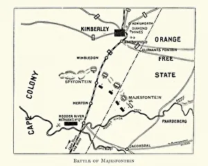
Plan of the Battle of MagersfonteinVintage engraving of a Plan of the Battle of Magersfontein, fought on 11 December 1899, at Magersfontein near Kimberley on the borders of the Cape Colony
Plan of the battlefield of The Battle of KAoniggrAÔé¼tz, also known as the Battle of Sadowa, SadovAaIllustration of a Plan of the battlefield of The Battle of KAoniggrAÔé¼tz, also known as the Battle of Sadowa, SadovAa, or Hradec KrAalovA©, was the decisive battle of the Austro-Prussian War
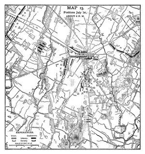
Gettysburg Battle Map Positions July 1st 1861 - Scanned 1887 Engraving
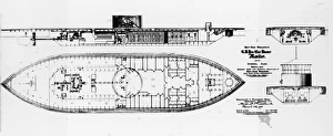
American Civil WarUSS Monitor, general plan published in 1862, showing the ships inboard profile, plan view below the upper deck and hull cross sections through the engine and boiler spaces
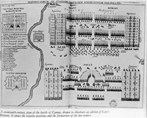
Battle of CannaeAn Engraving of a Seventeenth-Century Plan of the Battle of Cannae, circa 1650. (Photo by Fotosearch/Getty Images)
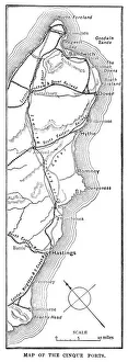
Map of the Cinque Ports (Victorian engraving)An old map of the Cinque Ports, which are five historic ports on the south-eastern corner of Kent, England. The Confederation of Cinque Ports (Cinque is pronounced asinka)
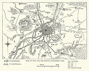
Franco Prussian War - Plan of Metz and French campVintage engraving of a scene fro the Franco Prussian War. Plan of Metz and French entrenched camp
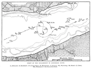
Battle Chart of the engament in Albemarle Sound - scanned 1888 chart
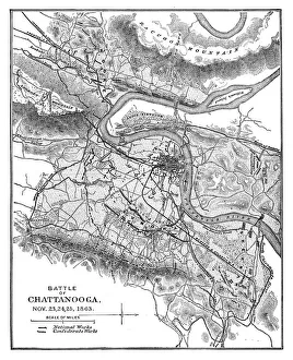
Battle Of Chattanooga Map - 1886 scanned engraving
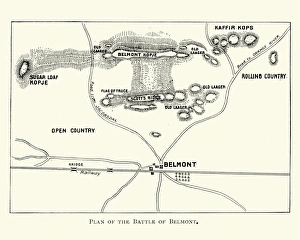
Second Boer War - Battle of BelmontVintage engraving of a plan of the Battle of Belmont an engagement of the Second Boer War on 23 November 1899, where the British under Lord Methuen assaulted a Boer position on Belmont kopje
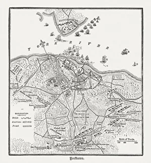
Battle of Yorktown in 1781, wood engraving, published in 1884Plan of the Battle of Yorktown during the American Revolutionary War in 1781. Wood engraving, published in 1884
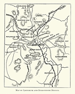
Second Boer War - Plan Ladysmith and surrounding heightsVintage engraving of a Plan Ladysmith and surrounding heights. 1899
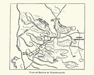
Second Boer War - Plan of the Battle of ElandslaagteVintage engraving of The Battle of Elandslaagte was a battle of the Second Boer War, and one of the few clear-cut tactical victories won by the British during that conflict
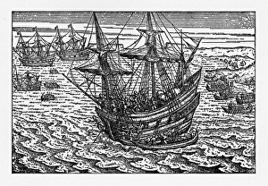
Engraving of Van Noort Landing in Manila Bay, Philippines, 1600Very Rare, Beautifully Illustrated Antique Engraved Victorian Illustration of Historical Engraving of Van Noort Landing in Manila Bay, Philippines, 1600. Copyright has expired on this artwork
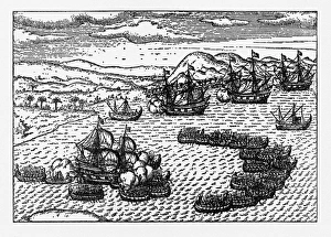
Historical Map of Dutch Navigators Battle in Portugal IllustrationVery Rare, Beautifully Illustrated Antique Engraved Victorian Illustration of Historical Map of Dutch Navigators Battle in Portugal Illustration. Copyright has expired on this artwork
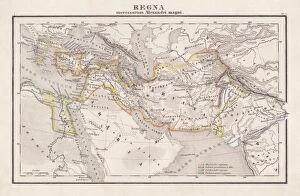
Empire of Alexander the Great, hand-coloured steel engraving, published 1861Antique map from Empire of Alexander the Great 356 - 326 BC) after the battle of Ipsos (301 BC). Legend in Latin language. Steel engraving with hand colored borderlines, published in 1861
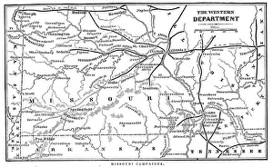
Missouri CampaignsVintage engraving from 1863 of a map of the Missouri Campaigns from the time of the American Civil War
Plan of action at the Battle on Breeds HillVintage engraving of the Plan of action at the Battle of Breeds Hill (also known as the Battle of Bunker Hill), Near Boston on 17th June 1775. Part of the American War of IndependenceView more
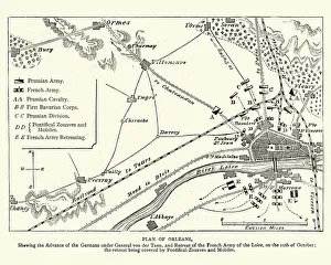
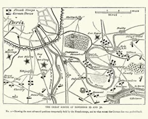
Franco Prussian War - Plan of Second Battle of OrleansVintage engraving of a scene from the Franco Prussian War. Plan of the Second Battle of Orleans, 1870
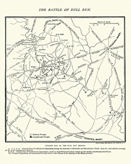
Map of the Battle of Bull RunVintage engraving of a Map of the Battle of Bull Run, The Century Magazine, 1884
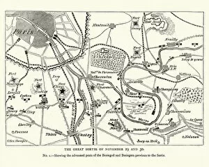
Franco Prussian War Battle plan of Siege of ParisVintage engraving of a scene from the Franco Prussian War. Battle plan of Siege of Paris
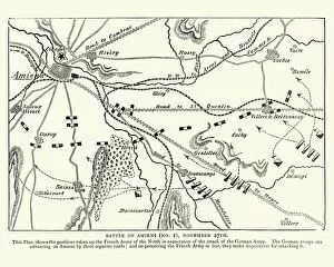
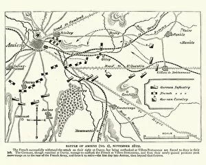
Franco Prussian War plan of the Battle of AmiensVintage engraving of a scene from the Franco Prussian War. plan of the Battle of Amiens
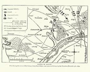
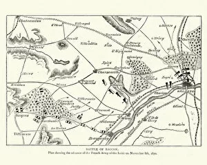
Franco Prussian War Plan of the Battle of CoulmiersVintage engraving of a scene from the Franco Prussian War. Plan of the Battle of Coulmiers (Baccon), The Battle of Coulmiers was fought on November 9
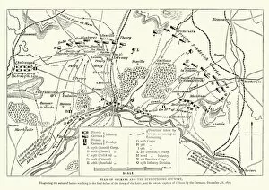
Franco Prussian War Battle plan of Siege of OrleansVintage engraving of a scene from the Franco Prussian War. Battle plan of Siege of Orleans
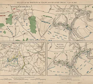
Napoleonic WarsPlans of the battle of Ligny and Quatre-Bras in Belgium during the Napoleonic Wars, 16th June 1815. Here Napoleon Bonaparte defeated the Prussian Army under Gebhard von Blucher
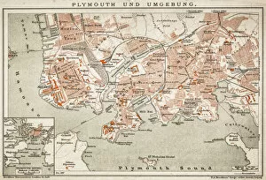
Plymouth and the surrounding area
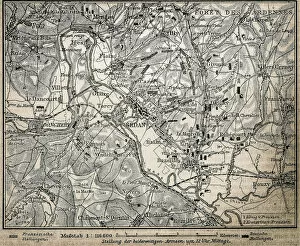
Battle of the ArdennesAntique illustration of a battle of Ardennes map