mail_outline sales@mediastorehouse.com
213 items
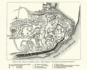
Plan of the Battle of Quebec (1775)Vintage engraving of Plan of the Battle of Quebec (1775). The Battle of Quebec (French: Bataille de Quebec) was fought on December 31, 1775
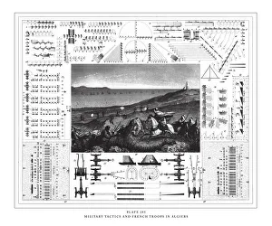
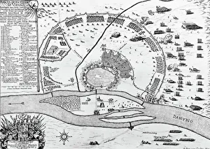
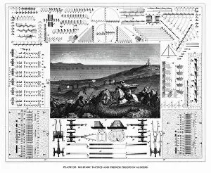
Military Tactics and French Troops in Algiers Engraving Antique Illustration, Published 1851. Source: Original edition from my own archives. Copyright has expired on this artwork. Digitally restored
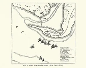
Plan of the Battle of Sullivans Island, 1776Vintage engraving of plan of the Battle of Sullivans Island or the Battle of Fort Sullivan was fought on June 28, 1776, during the American Revolutionary War
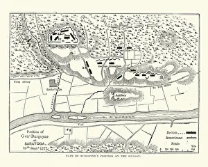
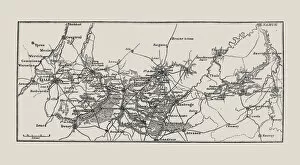
General John Burgoyne position, Battles of SaratogaVintage engraving of Map of General John Burgoyne position on the Hudson, Battles of Saratoga, American Revolutionary War
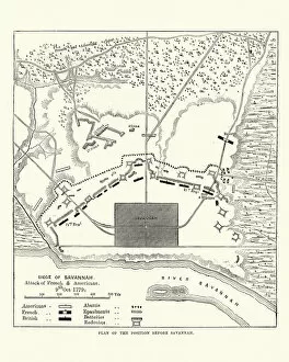
Plan of the Siege of Savannah, 1779, American Revolutionary WarVintage engraving of a plan of the Siege of Savannah or the Second Battle of Savannah was an encounter of the American Revolutionary War (1775-1783), in 1779
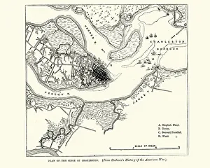
Plan of the Siege of Charleston, American Revolutionary WarVintage engraving of a Plan of the Siege of Charleston a major engagement and major British victory, fought between March 29 to May 12, 1780 during the American Revolutionary War
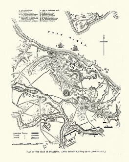
Plan of Siege of Yorktown, Virginia, American Revolutionary WarVintage engraving of Plan of Siege of Yorktown, Virginia, American Revolutionary War
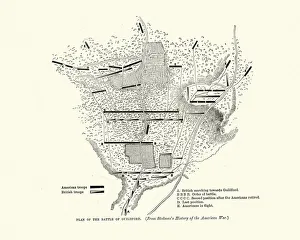
Plan of Battle of Guilford Court House, American Revolutionary WarVintage engraving of Plan of Battle of Guilford Court House, American Revolutionary War. The Battle of Guilford Court House was fought on March 15, 1781, during the American Revolutionary War
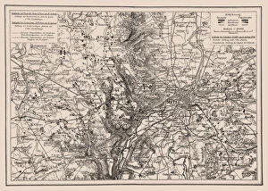
Battles near Metz, Franco-Prussian War in 1870Illustration of a Battles near Metz, Franco-Prussian War in 1870
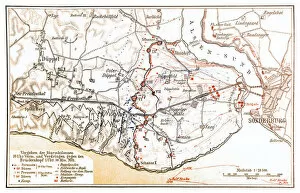
Battle of Dybbol mapIllustration of a Battle of Dybbol map
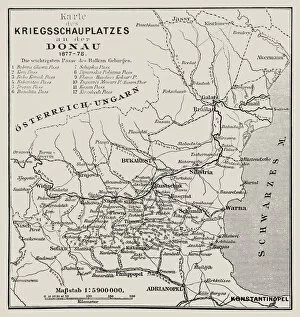
Map of the theater of war on the Danube 1877-78Illustration of a Map of the theater of war on the Danube
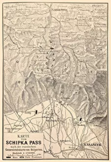
Battle of Shipka Pass MapIllustration of a Battle of Shipka Pass Map
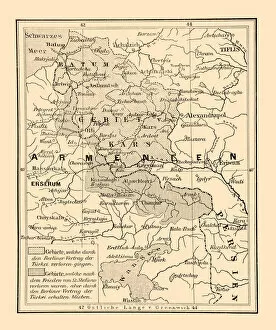
The borders of Asian Turkey after the Berlin TreatyIllustration of a The borders of Asian Turkey after the Berlin Treaty
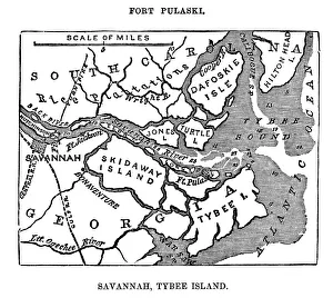
Fort Puaski In Savannah, GeorgiaEngraving From 1863 Showing Savannah, Tybee Island, And Fort Pulaski During The Civil War
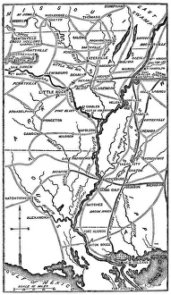
Southern USA From The Civil WarEngraving From 1863 Featuring The Southern American States Of Louisiana, Arkansas, And Missouri From The Time Of The American Civil War
Map of nautical battle with Russian navy1813, antiquity, archival, battle, cartography, geographical, geograph, Battle Maps and Plans, 87723369
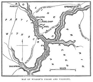
Battle of Wilsons Creek" Vintage engraving from 1863 of a map of the Battle of Wilsons Creek. The Battle of Wilsons Creek, also known as the Battle of Oak Hills, was fought on August 10, 1861, near Springfield
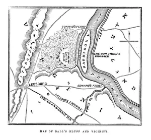
Map of Balls Bluff" Vintage engraving from 1863 of a map of Balls Bluff at the time of the American Civil War. The Battle of Balls Bluff, also known as the Battle of Harrisons Island or the Battle of Leesburg
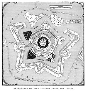
Fort Jackson, Louisiana" Vintage engraving from 1863 of a map of Fort Jackson, Louisiana. Fort Jackson was the site of the Battle of Forts Jackson and St
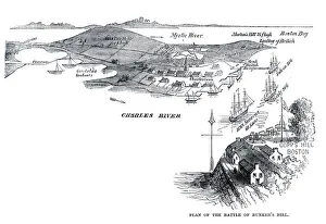
Battle of Bunker Hill" Vintage engraving from 1861 showing the Plan of the Battle of Bunker Hill. The Battle of Bunker Hill took place on June 17, 1775, mostly on and around Breeds Hill
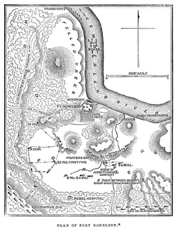
Battle of Fort Donelson" Vintage engraving from 1863 of a map of the Battle of Fort Donelson which was fought from February 11 to February 16, 1862, in the Western Theater of the American Civil War
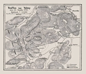
Map of Battle at Valmy 20. 9. 1792Illustration of a Map of Battle at Valmy 20.9.1792
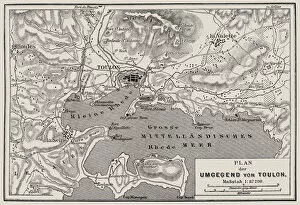
Plan of the surrounding of ToulonIllustration of a Plan of the surrounding of Toulon
Map of the First Battle of Teb, and Suakim, 1884Vintage engraving of Map of the First Battle of Teb, and Suakim, 1884, 19th Century. The Graphic 1884
Plan of the Battle of Son Tay, 1883Vintage engraving of Plan of the Battle of S?n Tay, French forces attacking the Black Flag Arm, Tonkin (northern Vietnam). The Graphic, 1884
French revolution, terrain Map of the wartime event of April 1792Illustration of a French revolution, terrain Map of the wartime event of April 1792
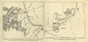
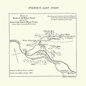
Map of the Shangani Patrol and Major Wilsons Last StandVintage engraving of a Map of the Shangani Patrol and Major Wilsons Last Stand. The Shangani Patrol (or Wilsons Patrol), comprising 34 soldiers in the service of the British South Africa Company
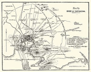
Third Carlist War - Siege of CarthagenaVintage engraving showing a plan of the Siege of Carthagena (Cartagena), Spain, during the Third Carlist War. The Carlist Wars were a series of civil wars that took place in Spain during the 19th
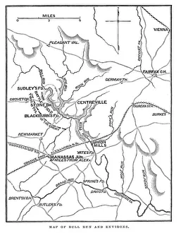
Battle of Bull RunVintage engraving from 1863 of a map of Bull Run and its environs at the time of the American Civil War. The First Battle of Bull Run
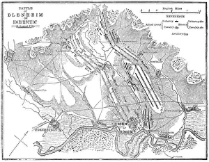
Battle of Blenheim (Hoechstedt) - map drawn in 1880Map of the Battle of Blenheim (Hoechstedt) which took place on 13 August 1704, during the War of the Spanish Succession. The English commander was John Churchill
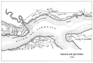
Antique Map of the Siege of Quebec - 18th CenturyVintage map of the Siege of Quebec in Quebec, Canada. Vintage etching circa late 19th century
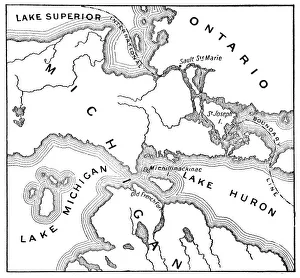
Antique Map of the Mackinac Island Area during the War of 1812 - 19th CenturyVintage map showing early territorial borders and military positions in the Mackinac area during the War of 1812. Vintage etching circa late 19th century
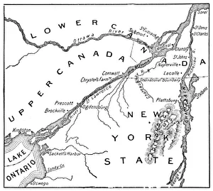
Antique Map of St. Lawrence Area during the War of 1812 - 19th CenturyVintage map showing early territorial borders and military positions in the St Lawrence area during the War of 1812. Vintage etching circa late 19th century
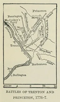
Old engraved map of the battle of Trenton and Princeton, 1776-1777Antique Illustration. Copyright has expired on this artwork. From my own archives, digitally restored. The Battle of Trenton was a small but pivotal American Revolutionary War battle on the morning
Defeat of the Ottoman Empire in Vienna in 1683: Plan of the siege of ViennaThe Great Turkish War between the Holy League of European Powers and the Ottoman Empire, also known as the Great Turkish War of Leopold I or the 5th Austrian Turkish War, lasted from 1683 to 1699
Defeat of the Ottoman Empire in Vienna in 1683: Vienna with the destroyed suburbsThe Great Turkish War between the Holy League of European Powers and the Ottoman Empire, also known as the Great Turkish War of Leopold I or the 5th Austrian Turkish War, lasted from 1683 to 1699
Defeat of the Ottoman Empire in Vienna in 1683: Shelling of the city by the OttomansThe Great Turkish War between the Holy League of European Powers and the Ottoman Empire, also known as the Great Turkish War of Leopold I or the 5th Austrian Turkish War, lasted from 1683 to 1699
Defeat of the Ottoman Empire in Vienna in 1683: siege work against the castle bastionThe Great Turkish War between the Holy League of European Powers and the Ottoman Empire, also known as the Great Turkish War of Leopold I or the 5th Austrian Turkish War, lasted from 1683 to 1699
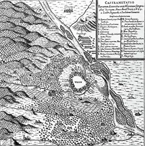
Defeat of the Ottoman Empire in Vienna in 1683: Turks camp at the beginning of the siegeThe Great Turkish War between the Holy League of European Powers and the Ottoman Empire, also known as the Great Turkish War of Leopold I or the 5th Austrian Turkish War, lasted from 1683 to 1699
Defeat of the Ottoman Empire in Vienna in 1683: Turks camp at the end of the siegeThe Great Turkish War between the Holy League of European Powers and the Ottoman Empire, also known as the Great Turkish War of Leopold I or the 5th Austrian Turkish War, lasted from 1683 to 1699
Military Tactics and French Troops in Algiers EngravingEngraved Illustrations of Military Tactics and French Troops in Algiers from Iconographic Encyclopedia of Science, Literature and Art, Published in 1851. Copyright has expired on this artwork
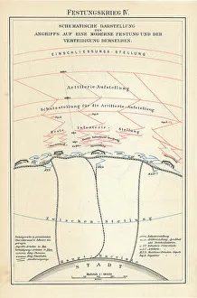
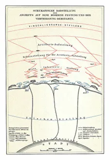
Old chromolithograph illustration of schematic representation of an attack on a modern fortressCopyright has expired on this artwork. From my own archives, digitally restored
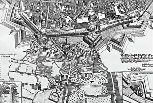
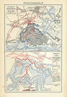
Old chromolithograph map of siege of Strasbourg, FranceCopyright has expired on this artwork. From my own archives, digitally restored
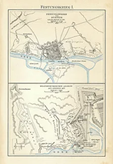
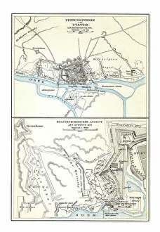
Old chromolithograph map of fortifications of Szczecin - Brandenburg attack on Stettin (1677)Copyright has expired on this artwork. From my own archives, digitally restored
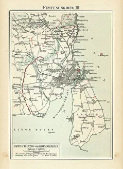
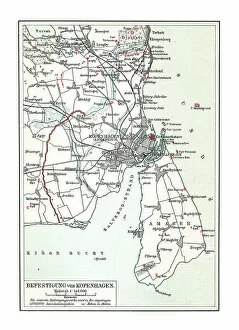
Old chromolithograph map of fortification of Copenhagen, Denmark (fortress war)Copyright has expired on this artwork. From my own archives, digitally restored