Home > History > Battles & Wars > Historcal Battle Maps and Plans
Tote Bag : Map of Bonnie Prince Charlies Wanderings


![]()
Home Decor from Fine Art Storehouse
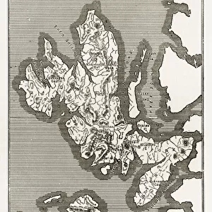
Map of Bonnie Prince Charlies Wanderings
Vintage caricature of Map of Bonnie Prince Charlies Wanderings after his defeat at the Battle of Culloden in 1746
duncan1890
Media ID 13667047
© duncan1890
18th Century 18th Century Style 78272 Equipment Hebrides Highland Image Created 18th Century Inner Hebrides Navigational Equipment Northern Europe Outer Hebrides Scotland Scottish Culture Scottish Highlands Styles
Canvas Tote Bag
Our tote bags are made from soft, durable, poly-poplin fabric and include a one inch (2.5cm) black strap for easy carrying on your shoulder. All seams are double-stitched for added durability. Each tote bag is machine-washable in cold water and is printed on both sides using the same image. Approximate size of bag is 50x33cm (20"x13")
Our tote bags are made from soft durable fabric and include a strap for easy carrying
Estimated Product Size is 50cm x 32.7cm (19.7" x 12.9")
These are individually made so all sizes are approximate
FEATURES IN THESE COLLECTIONS
> History
> Battles & Wars
> Historcal Battle Maps and Plans
> Map
> Historical Maps
> Map
MADE IN THE UK
Safe Shipping with 30 Day Money Back Guarantee
FREE PERSONALISATION*
We are proud to offer a range of customisation features including Personalised Captions, Color Filters and Picture Zoom Tools
SECURE PAYMENTS
We happily accept a wide range of payment options so you can pay for the things you need in the way that is most convenient for you
* Options may vary by product and licensing agreement. Zoomed Pictures can be adjusted in the Cart.