mail_outline sales@mediastorehouse.com
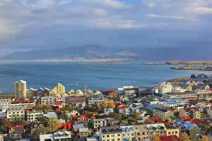
Aerial view over downtown Reykjavik with ocean and mountain at back, IcelandAerial view over downtown Reykjavik from the top of Hallgrimskirkja church with ocean and mountain at back, capital city of Iceland
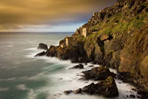
Botallack Long ExposureA long exposure of the abandoned tin mines at Botallack, Cornwall in the west of Cornwall, England, UK. Since 2006 it has been part of the UNESCO World Heritage Site - Cornwall
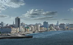
Havana. View of El MaleconThe MalecAon (officially Avenida de Maceo) is a broad esplanade, roadway and seawall which stretches for 8Akm (5 miles) along the coast in Havana, Cuba
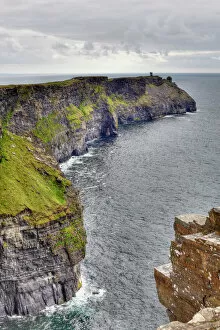
Hags Head, Cliffs of Moher, County Clare, Ireland, Europe
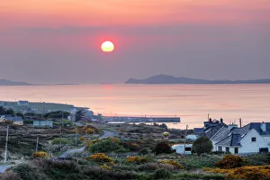
Cleggan at sunset, Connemara, County Galway, Republic of Ireland, Europe
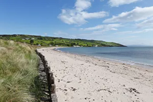
Sandy beach in Cushendun, County Antrim, Northern Ireland, Ireland, Great Britain, Europe
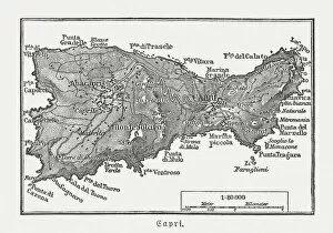
Map of Capri, Italian island, wood engraving published in 1897Map of Capri, Italian island. Wood engraving, published in 1897
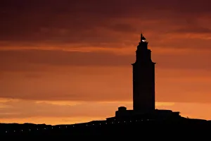
Silhouette of Hercules Tower at orange sunsetAn Unesco World Heritage site, Hercules Tower at night in A Coruna, a lighthouse in the north of Spain
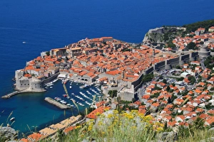
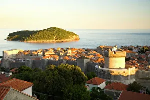
View of Old Town, the walled city of Dubrovnik, UNESCO World Heritage Site, Dalmatia, CroatiaDubrovnik is one of the most prominent tourist destinations in the Mediterranean Sea, a seaport on the Dalmation coast. In 1979, the city of Dubrovnik joined the UNESCO list of World Heritage Sites
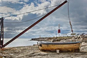
Portland Bill LighthouseThe red and white lighthouse at Portland Bill, Dorset framed by a small boat and jib crane
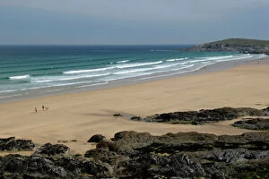
Fistral Beach, Newquay, Cornwall, England, United Kingdom
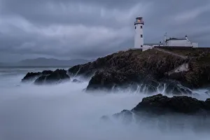
Fanad Lighthouse, Donegal, IrelandLong exposure image of Fanad Lighthouse off the coastline of Fanad, Donegal, Ireland
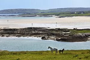
Coast at Claddaghduff with Omey Island, Connemara, County Galway, Republic of Ireland, Europe
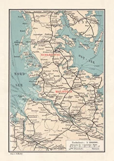
Map of Schleswig-Holstein, northernmost state of Germany, lithograph, published 1887Map of Schleswig-Holstein, northernmost state of Germany. Lithograph, published in 1887
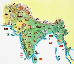
India, map with illustrations showing distinguishing features
Strandhill beach on the Wild Atlantic Way coastal routeCounty Sligo, Ireland
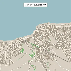
Margate Kent UK City Street MapVector Illustration of a City Street Map of Margate, Kent, UK. Included files are EPS (v10) and Hi-Res JPG. Data courtesy from Ordnance Survey: VectorMap District https
Waianapanapa SunriseThe Road to Hana is an amazing and probably Mauis most popular drive. One of the must stops on the way is the black sand beach. The water is cold, treacherous and shark infested
Historical map of Palestine with the twelve tribes of Israel. Colored steel engraving, published in 1886
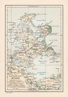
Map of RAOEgen, Baltic Sea, largest island of Germany, lithographMap of RAOEgen - Germanys largest island in the Baltic Sea. Lithograph, published in 1884
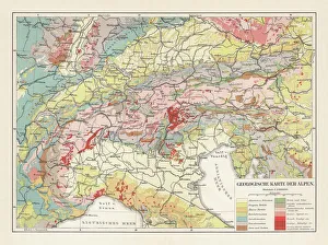
Geological map of the European Alps, lithograph, published in 1897Geological map of the European Alps. Lithograph, published in 1897
Reflections On Chestermans Beach Of Frank Island Near TofinoBritish Columbia, Canada
Cliff Baths at Beach of Enniscrone of County Sligo in IrelandAbandoned building which used to have a seaweed bath inside at beach of Enniscrone in County Sligo of Connacht province in Ireland
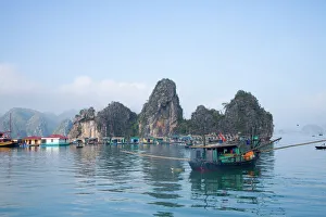
Floating Vietnamese fishing village with rocky coastline
Northern Ireland, Country Antrim, White Park Bay. An abandoned Youth Hostel overlooking White Park Bay part of the Giants Causeway World Heritage Site (UNESCO)
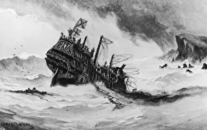
HMS RevengeThe remains of the British galleon HMS Revenge are dashed against the cliffs of Terceira in the Azores, to be lost evermore in the main, 1591
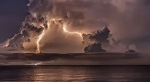
Catumbo Lightning over VenezuelaThere is a methane area 40 miles inland of Venezuela that has more lightning strikes than anywhere else in the world -Taken from Curacao
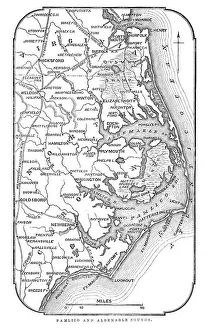
Map of Pamlico and Albemarle SoundsVintage engraving from 1863 of a map of Map of Pamlico and Albemarle Sounds at the time of the American Civil War
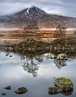
Loch na h-Achlaise Reflections, Rannoch Moor ScotlandSpectacular dramatic weather creates a moody atmosphere over the Mountains of Loch na h-Achlaise. The tranquil water of the loch reflects the distant mountains, islands of trees
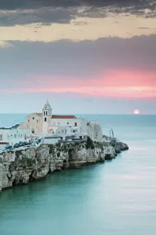
Sunrise over old town of Vieste, Gargano, Puglia, ItalyVieste, Gargano peninsula, Apulia, Italy
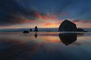
Cannon Beach at SunsetColorful Sunset at Cannon Beach by Haystack Rock at the Oregon Coast during Low Tide
Bundoran, Donegal, IrelandScenery along the coastline of Bundoran in County Donegal, Ireland
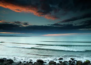
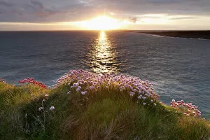
Marsh Daisy (Armeria maritima), coast at Doolin, County Clare, Ireland, Europe
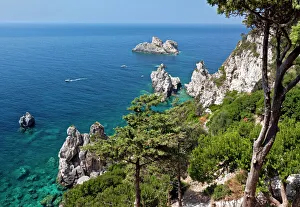
Wildly romantic coast near Paleokastritsa, Corfu Island, northwestern Corfu, Ionian Islands, Greece, Southern Europe
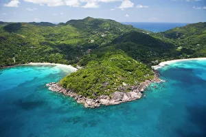
Anse Takamaka and Anse Intendance, Southern Mahe, Mahe, Seychelles, Africa, Indian Ocean
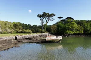
Shipwreck, Bere Haven Harbour, Dunboy near Castletownbere, Beara Peninsula, County Cork, Ireland, British Isles, Europe
Walled City of Dubrovnik, Southeastern Tip of Croatia, Dalmation Coast, Adriatic Sea, Croatia, Eastern Europe
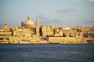
View of Valletta city (Malta) from the bay in Sliema. Warm light, sunset
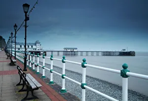
Promenade and pier in Penarth town outside Cardiff in South WalesPenarth, Wales
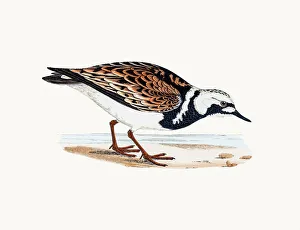
Turnstone birdA photograph of an original hand-colored engraving from The History of British Birds by Morris published in 1853-1891
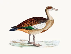
Egyptian gooseA photograph of an original hand-colored engraving from The History of British Birds by Morris published in 1853-1891
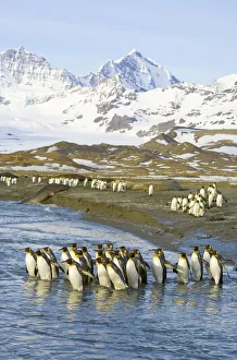
King penguins marching to sea to wash feathersKing penguins (Aptenodytes patagonicus) adult birds marching to sea together for morning wash of feathers to maintain their insulating qualities
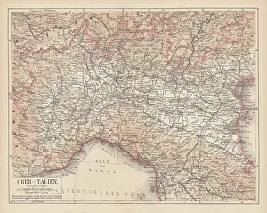
Ancient map of Northern Italy, lithograph, published in 1876Ancient map of Northern Italy. Lithograph, published in 1876
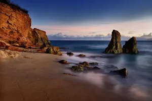
St MawesEngland, Cornwall, St Mawes, view
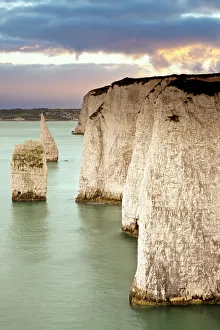
Cliffs at DorsetOld Harry chalk cliffs at Dorset
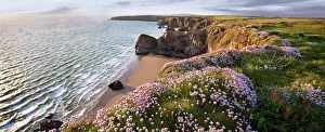
Magical CornwallSeascape of Bedruthan steps Cornwall
Cupecoy Beach, Saint Martin, French AntillesA long exposure of Cupecoy Beach coastal surf taken after sunset at twilight. Saint-Martin is one of five island dependencies of Guadeloupe. Situated in the French Antilles (French West Indies)