Home > The Magical World of Illustration > Nastasic Images & Illustrations
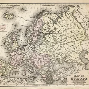
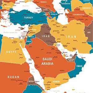
Political outline map of Europe

![]()
Wall Art and Photo Gifts from Fine Art Storehouse
Political outline map of Europe
Political outline map of Europe from 1898
Nastasic
Media ID 13593125
© Nikola Nastasic
62990 Earth Globe Man Made Object Globe Navigational Equipment Portugal Portuguese Culture World Map
FEATURES IN THESE COLLECTIONS
> The Magical World of Illustration
> Nastasic Images & Illustrations
> Map
> Historical Maps
> Map
> Italian Maps
> Map
MADE IN THE UK
Safe Shipping with 30 Day Money Back Guarantee
FREE PERSONALISATION*
We are proud to offer a range of customisation features including Personalised Captions, Color Filters and Picture Zoom Tools
SECURE PAYMENTS
We happily accept a wide range of payment options so you can pay for the things you need in the way that is most convenient for you
* Options may vary by product and licensing agreement. Zoomed Pictures can be adjusted in the Basket.