mail_outline sales@mediastorehouse.com
3,678 items
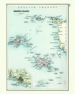
Antique map, Channel Island, Jersey, Guernsey, Alderney 19th CenturyVintage engraving of a Antique map, Channel Island, Jersey, Guernsey, Alderney 19th Century with detail of St Helier
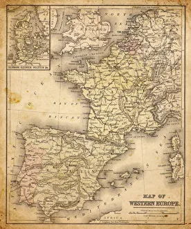
western europe map 1883a map of Western europe from 1883
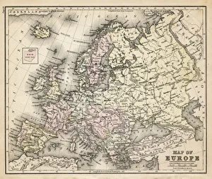
old map of european old map form 1883, showing european countries
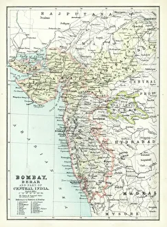
Antique map of Bombay, India, 19th CenturyAntique map of Bombay, Berar, and part of central India from 1891
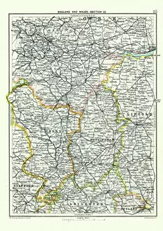
Antique map, West Yorkshire, Derby, Nottingham, Lincoln, 19th CenturyVintage engraving of a Antique map, West Yorkshire, Derby, Nottingham, Lincoln, Stafford, Leicester, Rutland, England. 19th Century
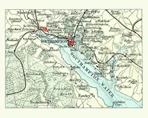
Antique map, Southampton, England, 19th CenturyVintage engraving of a Antique map Southampton, , England, 19th Century
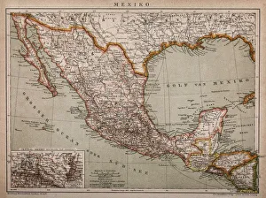
Map of MexicoAntique map of Mexico
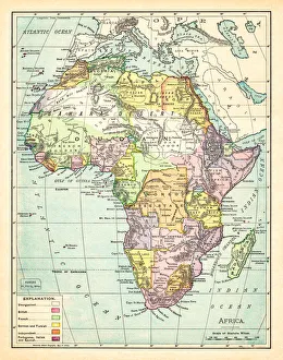
Map of Africa 1895The Rand-McNally Grammar School Geography 1895 - Chicago & New York
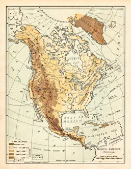
Physical map of North America 1895The Rand-McNally Grammar School Geography 1895 - Chicago & New York
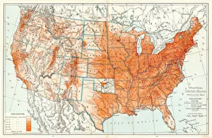
Political Map of United States 1895The Rand-McNally Grammar School Geography 1895 - Chicago & New York
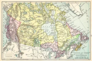
Map of Canada 1895The Rand-McNally Grammar School Geography 1895 - Chicago & New York
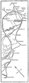
Antique Map of the Cinque Ports, (French: Five Ports) - 19th CenturyCinque Ports, (French: Five Ports) medieval confederation of English Channel ports in southeastern England, formed to furnish ships and men for the king's service
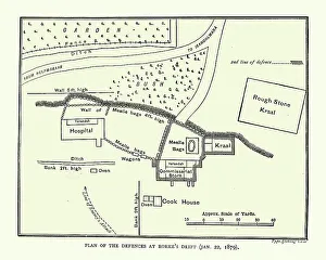
Plan of the Defence of Rorke's Drift, Anglo-Zulu WarVintage engraving of Plan of the Defence of Rorke's Drift, was an engagement in the Anglo-Zulu War. The successful British defence of the mission station of Rorke's Drift
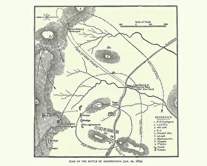
Plan of the Battle of Isandlwana, Anglo-Zulu WarVintage engraving of Plan of the Battle of Isandlwana the first major encounter in the Anglo-Zulu War between the British Empire and the Zulu Kingdom
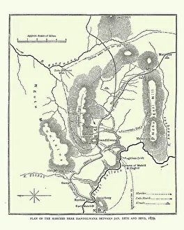
Map of the area around Isandlwana, Anglo-Zulu War, 1879Vintage engraving of Map of the area around Isandlwana, Anglo-Zulu War, 1879
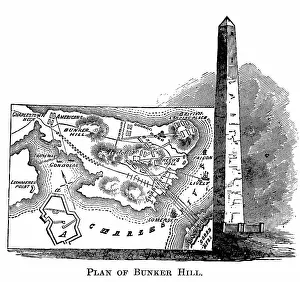
Engraved illustration of Plan of the Battle of Bunker Hill, 1775. Bunker Hill MonumentCopyright has expired on this artwork. From my own archives, digitally restored. The Battle of Bunker Hill was fought on June 17.1775
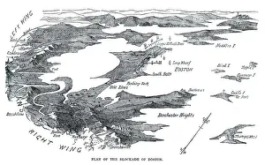
Blockade of BostonVintage engraving from 1861 showing the Plan of the Blockade of Boston during the American Revolutionary War
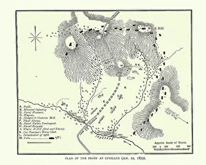
Plan of the Battle of Inyezane, or Siege of Eshowe, 1879Vintage engraving of Plan of the Battle of Inyezane, or Siege of Eshowewhich took place during the Anglo-Zulu War of 1879
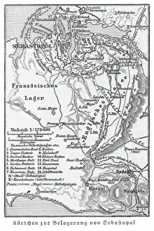
Old engraved map of the Siege of Sevastopol during the Crimean War, 1854 To 1855Copyright has expired on this artwork. From my own archives, digitally restored
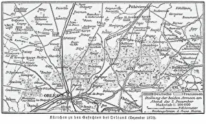
Old engraved map of Second Battle of Orleans, battle of the Franco-Prussian War of 1870Copyright has expired on this artwork. From my own archives, digitally restored
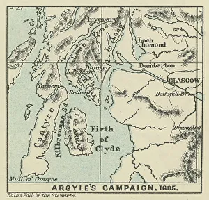
Old engraved map of Argyll's Rising, also known as Argyll's RebellionCopyright has expired on this artwork. From my own archives, digitally restored
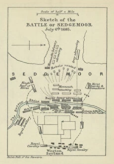
Old engraved map of Battle of the Sedgemoor (06. 07. 1685) - last and decisive engagement between the Kingdom ofCopyright has expired on this artwork. From my own archives, digitally restored
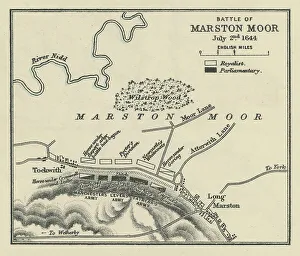
Old engraved map of Battle of Marston Moor (02. 07. 1644)Copyright has expired on this artwork. From my own archives, digitally restored
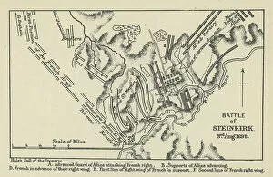
Old engraved map of Battle of Steinkirk, Steenkerke, Steenkirk or Steinkirk (03. 08. 1692) during the Nine Years WarCopyright has expired on this artwork. From my own archives, digitally restored
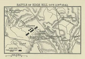
Old engraved map of Battle of Edge Hill (23. 10. 1642)Copyright has expired on this artwork. From my own archives, digitally restored. The Battle of Edgehill (or Edge Hill) was a pitched battle of the First English Civil War
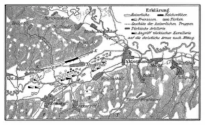
Old engraved map of the Battle of Saint Gotthard - part of the Austro-Turkish War (1663-1664)Copyright has expired on this artwork. From my own archives, digitally restored
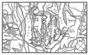
Old engraved map of Battle of Naseby (14. 06. 1645) - part of First English Civil WarCopyright has expired on this artwork. From my own archives, digitally restored. The Battle of Naseby took place on Saturday 14 June 1645 during the First English Civil War
Old engraved illustration of Battle of Zenta, also known as the Battle of Senta, was fought on 11 September 1697Copyright has expired on this artwork. From my own archives, digitally restored
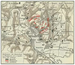
Old engraved map of Battle of Sedan, fought during the Franco-Prussian War from 1 to 2 September 1870Copyright has expired on this artwork. From my own archives, digitally restored
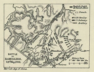
Old engraved map of Battle of Ramillies (23. 05. 1706) - battle of the War of the Spanish SuccessionCopyright has expired on this artwork. From my own archives, digitally restored
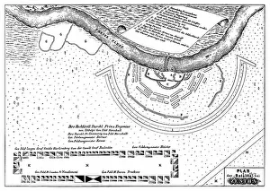
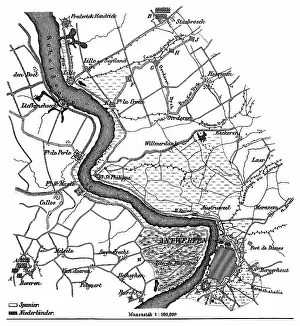
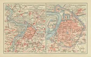
Old engraved map of the siege of Antwerp by Alexander Farnese from 10. 07. 1584 to 17. 08. 1585Copyright has expired on this artwork. From my own archives, digitally restored
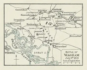
Old engraved map of Battle of Wagram (5 and 6 July 1809)Copyright has expired on this artwork. From my own archives, digitally restored
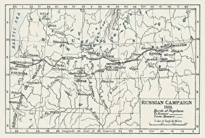
Old engraved illustration of Russian Campaign (1812), French occupation of Moscow, March of Napoleon to MoscowCopyright has expired on this artwork. From my own archives, digitally restored
Old chromolithograph map of Antwerp, largest city in Belgium, capital of Antwerp Province in the Flemish RegionCopyright has expired on this artwork. From my own archives, digitally restored
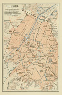
Old chromolithograph map of Brussels, officially the Brussels-Capital RegionCopyright has expired on this artwork. From my own archives, digitally restored
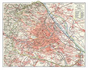
Old chromolithograph map of Vienna, national capital, largest city, and one of nine states of AustriaCopyright has expired on this artwork. From my own archives, digitally restored
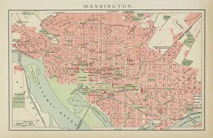
Old engraved map of City of Washington, USACopyright has expired on this artwork. From my own archives, digitally restored
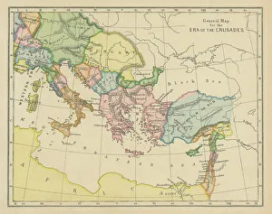
Old chromolithograph general map of era of the CrusadesCopyright has expired on this artwork. From my own archives, digitally restored
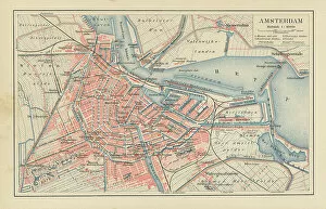
Old chromolithograph map of Amsterdam, capital and most populous city of the NetherlandsCopyright has expired on this artwork. From my own archives, digitally restored
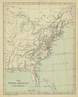
Old chromolithograph map the North American ColoniesCopyright has expired on this artwork. From my own archives, digitally restored
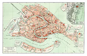
Old chromolithograph map of Venice, ItalyCopyright has expired on this artwork. From my own archives, digitally restored
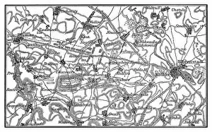
Old engraved map of the Battle of Kolin on 18 June 1757 saw 54, 000 Austrians under Count von Daun defeat 34Copyright has expired on this artwork. From my own archives, digitally restored
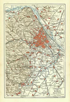
Old chromolithograph map of surroundings of Vienna, national capital, largest city, and one of nine states of AustriaCopyright has expired on this artwork. From my own archives, digitally restored
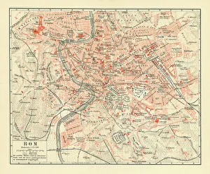
Old chromolithograph map of Rome, ItalyCopyright has expired on this artwork. From my own archives, digitally restored
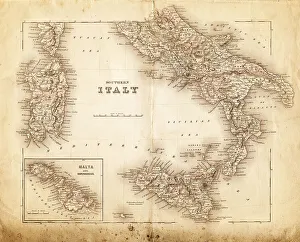
map of italy 1855an old map of southern italy (inset showing malta) - 1855
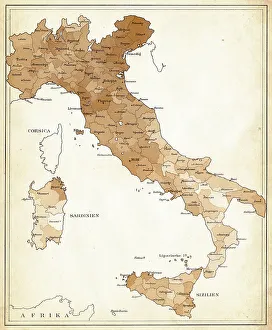
Map of Iltaly 1894Der Menfch Vol 2 by Johannes Ranke - Leipzig 1894
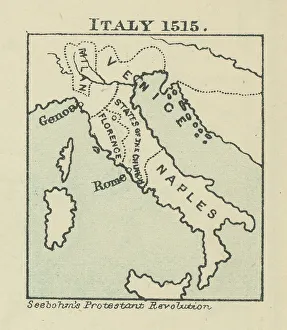
Old chromolithograph map of Italy in 1515Antique Illustration. Copyright has expired on this artwork. From my own archives, digitally restored
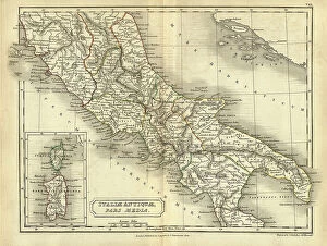
Antique map of Central Italy in Ancient times, Roman, Italiae Antiquae pars mediaVintage illustration of Antique map of Central Italy in Ancient times, Italiae Antiquae pars media. Atlas of Ancient Geography. By Samuel Butler