mail_outline sales@mediastorehouse.com
3,678 items
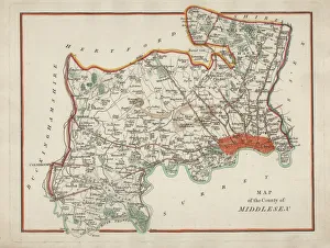
Antique Map of MiddlesexAn antique map of Middlesex engraved by R. Scott and published by Archibald Fullarton and Co. Glasgow. c. 1833. folding copy, later hand colouring
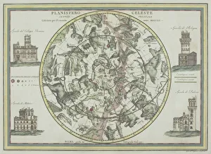
Antique star chart with zodiac signs18th century, antique, architecture, astrological, border, buildings, , Celestial Maps, 87671786
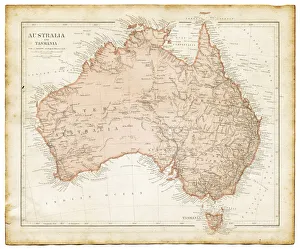
Old map of Australia 1899an old map of Australia 1899 - combined with several different textures and grunge papers
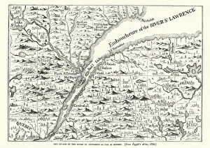
Map of the St Lawrence river, 18th CenturyVintage engraving of a Map of the St Lawrence river, 18th Century
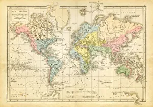
world map 1882french map of the world showing the trajectories of travels and discovery around 1780 and 1822 - map is from 1882
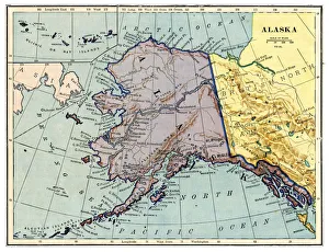
Map of Alaska 1889Comprehensive Geography by James Monteith - American Book Company 1882, 1889
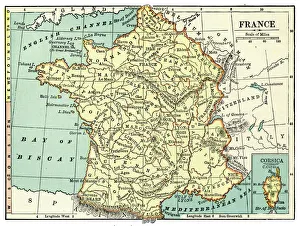
Map of France 1889Comprehensive Geography by James Monteith - American Book Company 1882, 1889
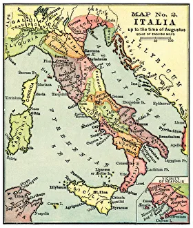
Map of Italy in the times of Augustus 1889Comprehensive Geography by James Monteith - American Book Company 1882, 1889
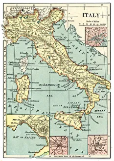
Map of Italy 1889Comprehensive Geography by James Monteith - American Book Company 1882, 1889
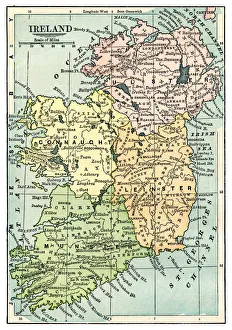
Map of Ireland 1889Comprehensive Geography by James Monteith - American Book Company 1882, 1889
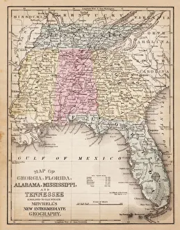
Map of USA Southern states 1881A System of Modern Geography designed for the use of schools and academies by Augustus Mitchell - Published by T. H. Butler / Philadelphia 1881
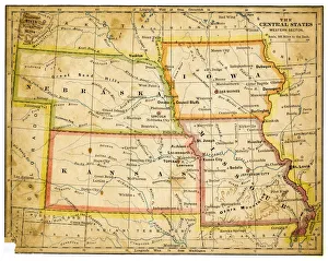
Map of USA Central states 1883The Eclectic Elementary Geography by Van Antwerp, Bragg & C0 / Cincinnati -New York 1883
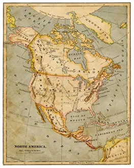
Map of North America 1883The Eclectic Elementary Geography by Van Antwerp, Bragg & C0 / Cincinnati -New York 1883
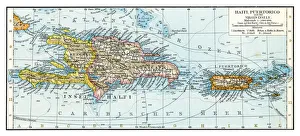
Haiti Puerto Rico map 1896Andres Allgemeiner Handatlas - Bielefeld und Leipzig 1896
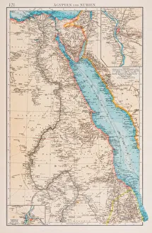
Map of Egypt and Sudan 1896Andres Allgemeiner Handatlas - Bielefeld und Leipzig 1896
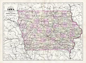
Map of Iowa USA 1894Johnsons Universal Cyclopedia - Volume IV New York - A. J. Johnson Company 1894
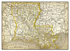
Map of Louisiana 1893New Pocket Atlas / Rand, McNally & Co -1893
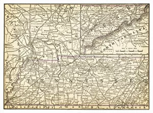
Map of Tennessee 1893New Pocket Atlas / Rand, McNally & Co -1893
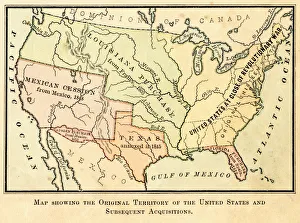
Map of the original USA territory 1881Appletons American Standard Geographies - New York 1881 - d. Appleton and Company
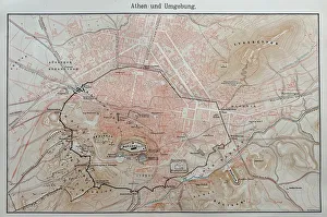
Map of ancient AthensIllustration from 19th century
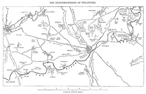
Old Map of the Stratford-on-Avon District of England circa 16th CenturyOld map of Stratford-upon-Avon and surrounding villages of the Stratford-on-Avon District, England from the Works of William Shakespeare. Vintage etching circa mid 19th century
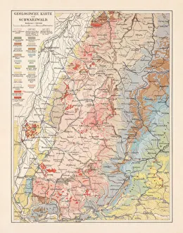
Geological map of the Black Forest, Baden-Wurttemberg, Germany, lithograph, 1897Geological map of the Black Forest, Baden-Wurttemberg, Germany. Lithograph, published in 1897
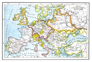
Europe after the Peace Treaty in Westphalia (1648)Illustration of a Europe after the Peace Treaty in Westphalia (1648)
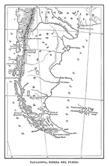
Map of Patagonia - Scanned 1880 Engraving
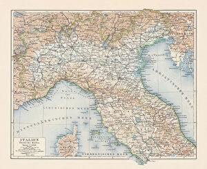
Topographic map of Northern Italy, lithograph, published 1897Topographic map of Northern Italy. Lithograph, published in 1897
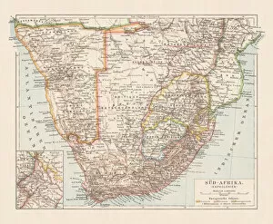
Topographic map of South Africa and Namibia, lithograph, published 1897Topographic map of South Africa during the Dutch and British colonial era as well as Namibia (Deutsch-SAOEdwestafrika) during the German colonial era at the end of the 19th century
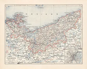
Historical map of Pomerania, Germany and Poland, lithograph, published 1897Historical map of Pomerania, German Empire (now Germany and Poland). Lithograph, published in 1897
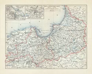
Map of East and West Prussia, Germany, lithograph, published 1897Historical topographic map of East and West Prussia in Germany (now Poland and Russia). Lithograph, published in 1897
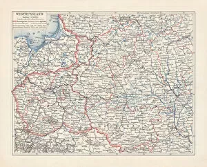
Map of Poland and Western Russia (Belarus), lithograph, published 1897Historical topographic map of Poland and Western Russia (Belarus). Lithograph, published in 1897
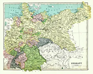
Antique map of Germany, 1897, late 19th CenturyVintage engraving of a Antique map of Germany, 1897, late 19th Century
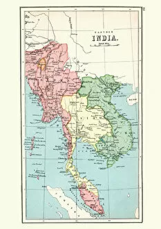
Antique map Burma, Thailand, Vietnam, Malaysia, 1897, late 19th CenturyVintage engraving of a Antique map of Burma, Thailand, Vietnam, Malaysia, 1897, late 19th Century
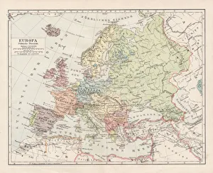
Map of Europe 1900Meyers hand-Atlas Leipzig und Wien Verlag des Bibliographischen Instituts 1900
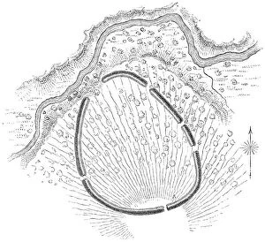
Squire Map of the Bone Fort near Oakfield in Genesee County, New York, USAThe Bone Fort near Oakfield in Genesee County, New York, United States of America. Map by Ephraim George Squier (circa mid 19th century). Vintage etching circa mid 19th century
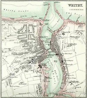
Map of WhitbyVintage map from 1880 of Whitby a town in North Yorkshire, England.++Inspector: Info about source material uploaded as property release++
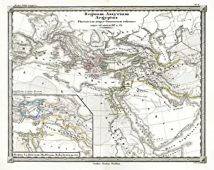
Antique Map of the Assyrian EmpireAntique Map from 1862 of Assyrian Empire also showing Phoenician and Greek colonies circa 627 BC. Maps text is written in Latin
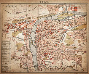
PragueAntique map of Prague from 1898
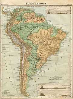
South America Map Illustration, Travel, Exploration, Antique 1871 IllustrationColor stock photo of an antique South America map illustration. Salvaged from an 1871 geography book
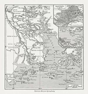
Historical map of the Pearl River Delta, woodcut, published 1897Historical map of the mouth of the Pearl River Delta (Zhujiang) with the locations of Guangzhou (Canton), Macau and Hong Kong at the end of the 19th century. Wood engraving, published in 1897
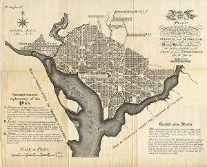
Early Map of the City and Capitol of Washington, D. C. United States, Antique American Illustration, 1900Antique American Photograph: Early Map of the City and Capitol of Washington, D.C. United States, Antique American Illustration, 1900: Original edition from my own archives
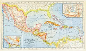
1883 Map Of Central America
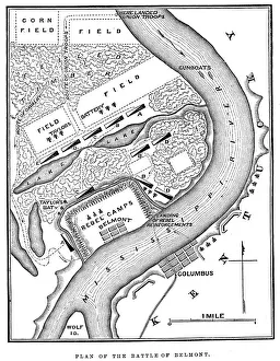
Battle of BelmontVintage engraving from 1863 of a map of the Battle of Belmont which was fought on November 7, 1861, in Mississippi County, Missouri. It was the first combat test in the American Civil War for Brig
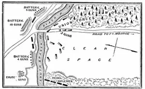
Battle of Big BethelVintage engraving from 1863 of a map of the Battle of Big Bethel also known as the Battle of Bethel Church or Great Bethel was an American Civil War battle that took place on June 10, 1861
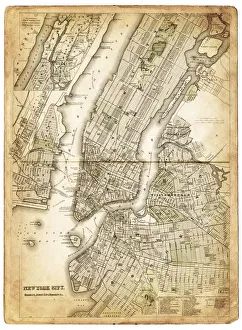
map of new york city 1874very old map showing new york city, new jersey, and hoboken) 1874 - composite with grunge sepia paper
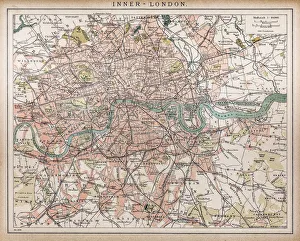
Historic map of London (18th Century)map/plan of the inner city of London from 1898
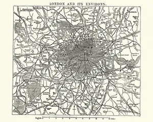
Map of Victorian London and its environs, England, 1870sVintage engraving of a Map of Victorian London and its environs, England, 1870s, 19th Century
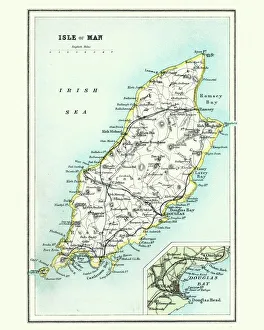
Antique map, Isle of Man 19th CenturyVintage engraving of a Isle of Man 19th Century with detail of Douglas
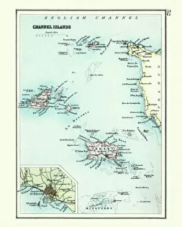
Antique map, Channel Island, Jersey, Guernsey, Alderney 19th CenturyVintage engraving of a Antique map, Channel Island, Jersey, Guernsey, Alderney 19th Century with detail of St Helier
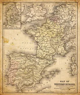
western europe map 1883a map of Western europe from 1883