Home > Map > Italian Maps
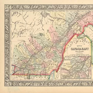
Victorian Map of Central Italy, Circa 1865

![]()
Wall Art and Photo Gifts from Fine Art Storehouse
Victorian Map of Central Italy, Circa 1865
Extremely Rare, Beautifully Illustrated Antique Victorian Engraved Illustration of the map of Central Italy including Tuscany, Parma and Modena from Liberators of Italy, A Book about General Garibaldias fight for the liberation of Italy. Published in 1865. Copyright has expired on this artwork. Digitally restored
bauhaus1000
Media ID 13666853
© Craig McCausland
1860 1869 66695 78279 Art Product Chart Diagram Drypoint Image Created 1860 1869 Isolated On White Italian Culture Plan Province Residential District Tuscany
FEATURES IN THESE COLLECTIONS
> Map
> Historical Maps
> Map
> Italian Maps
> Map
MADE IN THE UK
Safe Shipping with 30 Day Money Back Guarantee
FREE PERSONALISATION*
We are proud to offer a range of customisation features including Personalised Captions, Color Filters and Picture Zoom Tools
SECURE PAYMENTS
We happily accept a wide range of payment options so you can pay for the things you need in the way that is most convenient for you
* Options may vary by product and licensing agreement. Zoomed Pictures can be adjusted in the Basket.