Framed Print > Map > Map Illustrations
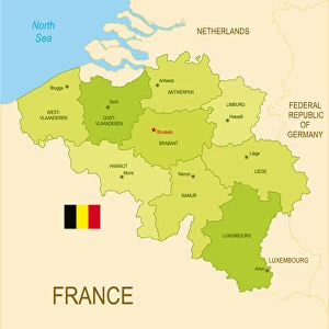
Framed Print : Belgium Vector Map


![]()
Framed Photos from Fine Art Storehouse
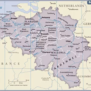
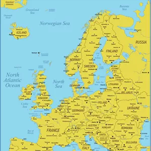
Belgium Vector Map
Highly detailed vector map of Belgium. File was created on July 14, 2011. The colors in the.eps-file are ready for print (CMYK). Included files: EPS (v8) and Hi-Res JPG
Frank Ramspott
Media ID 14833519
© Frank Ramspott, all rights reserved
Antwerp Atlantic Ocean Belgium Benelux Bruges Brussels Clip Art Computer Graphic Country Geographic Area Geology Green Hainaut Latitude Longitude Luxembourg North Sea Region Satellite View Square Vector View Into Land Wallonia West Flanders
12"x10" Modern Frame
10x8 Print in an MDF Wooden Frame with 180 gsm Satin Finish Paper. Glazed using shatter proof thin plexi glass. Frame thickness is 1 inch and depth 0.75 inch. Fluted cardboard backing held with clips. Supplied ready to hang with sawtooth hanger and rubber bumpers. Spot clean with a damp cloth. Packaged foam wrapped in a card.
Contemporary Framed and Mounted Prints - Professionally Made and Ready to Hang
Estimated Image Size (if not cropped) is 25.4cm x 25.4cm (10" x 10")
Estimated Product Size is 30.5cm x 25.4cm (12" x 10")
These are individually made so all sizes are approximate
Artwork printed orientated as per the preview above, with landscape (horizontal) or portrait (vertical) orientation to match the source image.
MADE IN THE USA
Safe Shipping with 30 Day Money Back Guarantee
FREE PERSONALISATION*
We are proud to offer a range of customisation features including Personalised Captions, Color Filters and Picture Zoom Tools
SECURE PAYMENTS
We happily accept a wide range of payment options so you can pay for the things you need in the way that is most convenient for you
* Options may vary by product and licensing agreement. Zoomed Pictures can be adjusted in the Cart.