
Topography Collection (page 3)

Background imageTopography Collection: Japan and Korea 1898

Japan and Korea 1898
Antique map of Japan and Korea from 1898

Background imageTopography Collection: Antique German atlas map close up: Australia

Antique German atlas map close up: Australia

Background imageTopography Collection: London city map

London city map

Background imageTopography Collection: Map of Frankfurt / Main and surroundings, Hesse, Germany, lithograph, published 1897

Map of Frankfurt / Main and surroundings, Hesse, Germany, lithograph, published 1897
Map of Frankfurt am Main and surroundings in Hesse, Germany. Lithograph, published in 1897

Background imageTopography Collection: Topographic map of the European Alps, lithograph, published in 1897

Topographic map of the European Alps, lithograph, published in 1897
Topographic map of the European Alps. Lithograph, published in 1897

Background imageTopography Collection: Historic city map of Belgrade, Serbia, wood engraving, published 1897

Historic city map of Belgrade, Serbia, wood engraving, published 1897
Historic city map of Belgrade - capital and largest city of Serbia. Wood engraving, published in 1897

Background imageTopography Collection: compass rose, equator, indian ocean, international dateline, map, melanesia

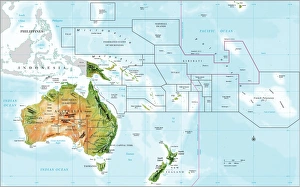
compass rose, equator, indian ocean, international dateline, map, melanesia, micronesia, new zealand, no people, oceania, pacific ocean, polynesia, relief map, topography, tropic of capricorn

Background imageTopography Collection: Netherlands map

Netherlands map
illustration of a Netherlands map

Background imageTopography Collection: Probable Settlement of the Descendants of Noah (steel engraving)

Probable Settlement of the Descendants of Noah (steel engraving)
A creased and stained steel engraving of a map which shows The Countries of the Ancient World Exhibiting the Probable Settlement of the Descendants of Noaha, from A System of Geography

Background imageTopography Collection: North America Physical Map, Engraving, 1892

North America Physical Map, Engraving, 1892
Very rare, beautifully detailed engraving of North America Physical Map, Engraving, Published in 1892. Original edition from my own archives. Copyright has expired on this artwork. Digitally restored

Background imageTopography Collection: Antique Map of Europe, 1785

Antique Map of Europe, 1785
An accurate map of Europe from the best authorities. London: C. Dilly & G. Robinson: 1785. Original size: 35.7 x 37.4 cm. Coloured, Inset: Spitsbergen, East and West Greenland, and Iceland

Background imageTopography Collection: City map of Thessaloniki, Greece

City map of Thessaloniki, Greece
Illustration of a city map of Thessaloniki, Greece

Background imageTopography Collection: Old, Map of Eastern and Western Hemispheres, From 1875

Old, Map of Eastern and Western Hemispheres, From 1875
Old black and white illustration of the Eastern Hemisphere and the Western Hemisphere, from the 1800 s

Background imageTopography Collection: close up, close-up, cropped, detailed, earth, europe, globe, nobody, on black, reversed

close up, close-up, cropped, detailed, earth, europe, globe, nobody, on black, reversed, studio shot, surface, texture, topographic, topography, upside down, Hemera, 87466809

Background imageTopography Collection: Turkey in Europe

Turkey in Europe
Vintage map of Turkey in Europe.Engraved, Published and Edited in 1845in the Pictorial Sunday-Book by J.Morrison&CoRestored By PictoreVery high resolution ( XXXL)

Background imageTopography Collection: Poland map

Poland map

Background imageTopography Collection: Antique map of lines of equal magnetic declination, 1885

Antique map of lines of equal magnetic declination, 1885

Background imageTopography Collection: North Africa: Algeria, Morocco and Tunisia, lithograph, published in 1897

North Africa: Algeria, Morocco and Tunisia, lithograph, published in 1897
Topographic map of Algeria, Morocco and Tunisia with the borders at the end of the 19th century. Lithograph, published in 1897

Background imageTopography Collection: Map of Belgium, lithograph, published in 1897

Map of Belgium, lithograph, published in 1897
Map of Belgium with the territorial language areas. Lithograph, published in 1897

Background imageTopography Collection: City map of Breslau, (today Wroclaw, Poland), lithograph, published 1897

City map of Breslau, (today Wroclaw, Poland), lithograph, published 1897
City map of Breslau, Prussia, Germany (today Wroclaw, Poland). Lithograph, published in 1897

Background imageTopography Collection: City map of Brunswick, Lower Saxony, Germany, lithograph, published 1897

City map of Brunswick, Lower Saxony, Germany, lithograph, published 1897
City map of Brunswick in Lower Saxony, Germany. Lithograph, published in 1897

Background imageTopography Collection: City map of Christiania (now Oslo), Norway, lithograph, published 1897

City map of Christiania (now Oslo), Norway, lithograph, published 1897
City map of Christiania, now Oslo - capital of Norway. Lithograph, published in 1897

Background imageTopography Collection: Map of formerly German colony East Africa, lithograph, published 1897

Map of formerly German colony East Africa, lithograph, published 1897
Map of the formerly German colony East Africa between 1885 and 1918, (present-day Burundi, Rwanda, and the mainland part of Tanzania). Lithograph, published in 1897

Background imageTopography Collection: Map of religious affiliation in Germany, lithograph, published in 1897

Map of religious affiliation in Germany, lithograph, published in 1897
Map of the religious affiliation in Germany at the end of the 19th century. Lithograph, published in 1897

Background imageTopography Collection: Population density of Germany in 1890, lithograph, published in 1897

Population density of Germany in 1890, lithograph, published in 1897
Map of the population density of Germany in 1890. Lithograph, published in 1897

Background imageTopography Collection: Pannonia

Pannonia is an ancient country of southern Europe that was south and west of the Danube River, in present-day Austria, Hungary, Slovenia, and Croatia

Background imageTopography Collection: Austro-Hungarian Monarchy map from 1896

Austro-Hungarian Monarchy map from 1896
illustration of a Austro-Hungarian Monarchy map from 1896

Background imageTopography Collection: Map of Palestine

Map of Palestine
Illustration of a map of Palestine

Background imageTopography Collection: Antique map of Asia Minor, present day Turkey

Antique map of Asia Minor, present day Turkey

Background imageTopography Collection: Battle of Yorktown in 1781, wood engraving, published in 1884

Battle of Yorktown in 1781, wood engraving, published in 1884
Plan of the Battle of Yorktown during the American Revolutionary War in 1781. Wood engraving, published in 1884

Background imageTopography Collection: Map of Brazil and Paraguay (early 19th century steel engraving)

Map of Brazil and Paraguay (early 19th century steel engraving)
A steel engraving of a map from the early 19th century of Brazil and Paraguay in South America, from A System of Geography, Popular and Scientific, or A Physical, Political

Background imageTopography Collection: Map of South America (early 19th century steel engraving)

Map of South America (early 19th century steel engraving)
A steel engraving of a map from the early 19th century of Brazil and Paraguay in South America, from A System of Geography, Popular and Scientific, or A Physical, Political

Background imageTopography Collection: Ancient map of the Arctic Region, lithograph, published in 1883

Ancient map of the Arctic Region, lithograph, published in 1883
Ancient map of the Arctic Region. Lithograph, published in 1883

Background imageTopography Collection: Empire of Alexander the Great, hand-coloured steel engraving, published 1861

Empire of Alexander the Great, hand-coloured steel engraving, published 1861
Antique map from Empire of Alexander the Great 356 - 326 BC) after the battle of Ipsos (301 BC). Legend in Latin language. Steel engraving with hand colored borderlines, published in 1861

Background imageTopography Collection: Seleucid Empire, 3rd to 2nd century BC, published in 1861

Seleucid Empire, 3rd to 2nd century BC, published in 1861
The Seleucid Empire was created after the death of Alexander the Great and dominated the Near East from the 3rd to 2nd century BC. Legend in Latin language

Background imageTopography Collection: China and Japan, lithograph, published in 1881

China and Japan, lithograph, published in 1881
Antique map of China and Japan. Lithograph, published in 1881

Background imageTopography Collection: Ottoman Empire, 14th-19th century, lithograph, published in 1878

Ottoman Empire, 14th-19th century, lithograph, published in 1878
Ancient map of the history of European Turkey, 15th - 19th century. Lithograph, published in 1878

Background imageTopography Collection: City map of Vienna, Austria, lithograph, published in 1878

City map of Vienna, Austria, lithograph, published in 1878
Ancient map of Vienna, Austria. Lithograph, published in 1878

Background imageTopography Collection: Silesia and Poznan, lithograph, published in 1878

Silesia and Poznan, lithograph, published in 1878
Ancient map of Silesia and Poznan, former territories of the German Empire, today Poland. Lithograph, published in 1878

Background imageTopography Collection: Special Geology Engraving

Special Geology Engraving
Engraved Illustrations of Special Geology Engraving from Iconographic Encyclopedia of Science, Literature and Art, Published in 1851. Copyright has expired on this artwork. Digitally restored

Background imageTopography Collection: Map of Baltic states, lithograph, published in 1877

Map of Baltic states, lithograph, published in 1877
Historic map of Baltic states: Lithuania, Estonia, Latvia. Lithograph, published in 1877

Background imageTopography Collection: Map of Alsace-Lorraine, lithograph, published in 1875

Map of Alsace-Lorraine, lithograph, published in 1875
Ancient map of Alsace-Lorraine (German: Elsass-Lothringen). Lithograph, published in 1875

Background imageTopography Collection: Map of China and Japan, lithograph, published in 1875

Map of China and Japan, lithograph, published in 1875
Map of China and Japan. Lithograph, published in 1875

Background imageTopography Collection: Antquie Map of South America

Antquie Map of South America
Vintage map of South America from 1837

Background imageTopography Collection: Map of Metz

Map of Metz
Antique map of fighting around Metz on the 14th, 16th and 18 August 1870th

Background imageTopography Collection: Prussia historical map

Prussia historical map
Illustration of a Prussia historical development map

Background imageTopography Collection: Siberia map, the Amur region

Siberia map, the Amur region
Illustration of a Siberia map, the Amur region

Background imageTopography Collection: Alexandria map

Alexandria map
Antique illustration of a Mediterranean Sea


All Professionally Made to Order for Quick Shipping