Home > Map > Historical Maps
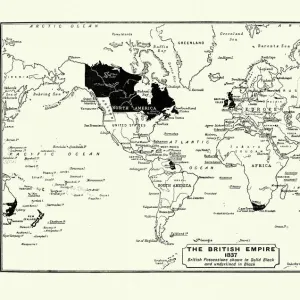
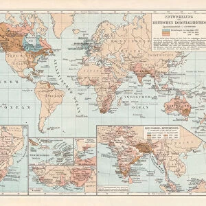
Map of the British Empire in 1897

![]()
Wall Art and Photo Gifts from Fine Art Storehouse
Map of the British Empire in 1897
Map of the British Empire in 1897. At its height, the British Empire was the largest empire in history and, for over a century, was the foremost global power
duncan1890
Media ID 13666687
© duncan1890
1890 1899 66698 78279 British Culture British Empire Empire Equipment Ilustration Image Created 1890 1899 Navigational Equipment Retro Revival Styles World Map
FEATURES IN THESE COLLECTIONS
> Map
> Historical Maps
> Map
MADE IN THE UK
Safe Shipping with 30 Day Money Back Guarantee
FREE PERSONALISATION*
We are proud to offer a range of customisation features including Personalised Captions, Color Filters and Picture Zoom Tools
SECURE PAYMENTS
We happily accept a wide range of payment options so you can pay for the things you need in the way that is most convenient for you
* Options may vary by product and licensing agreement. Zoomed Pictures can be adjusted in the Basket.