mail_outline sales@mediastorehouse.com
3,671 items
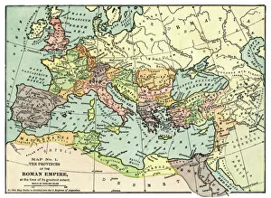
Map of the Roman Empire 1889Comprehensive Geography by James Monteith - American Book Company 1882, 1889
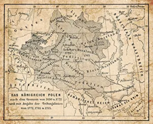
Map of Kingdom of Poland from 18th centuryIllustration of a Map of Kingdom of Poland from 18th century
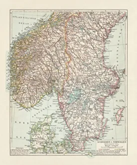
Map of Denmark, Southern Norway and Southern Sweden, lithograph, 1897Topographic map of Denmark, Southern Norway and Southern Sweden. Lithograph, published in 1897
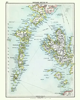
Antique map, Scotland, Isle of Skye, South and North UistVintage engraving of a Antique map, Scotland, Isle of Skye, South and North Uist, Rum 19th Century
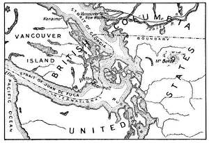
Antique Map of the San Juan Islands - 19th CenturyVintage map of the San Juan Islands. The area has been disputed since the 1850s, in the 21st century the area was finally recognized as the Salish Sea. Vintage etching circa late 19th century
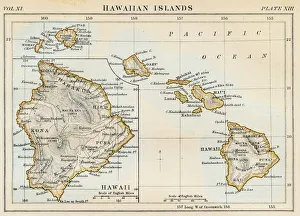
Map of Hawaiian islands 1883Encyclopedia Britannica 9th Edition New York Samuel L. Hall 1883 Vol XI
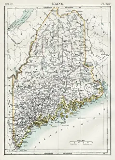
Map of Maine 1883Encyclopedia Britannica 9th Edition New York Samuel L. Hall 1883 Vol XV
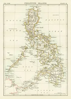
Philippines map 1885Encyclopedia Britannica 9th Edition New York Charles Scribners and Sons 1885 Vol XVIII
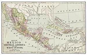
Map of Mexico and Central America 1889Indiana Educational Series The Complete Geography - Indianapolis 1889
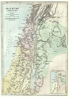
Map of Palestine in the time of Jesus ChristVintage engraving of Map of Palestine in the time of Jesus Christ
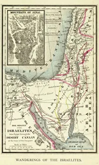
Wanderings of the Israelites Map EngravingEngraved illustration of Wanderings of the Israelites Map Engraving from The Popular Pictorial Bible, Containing the Old and New Testaments, Published in 1862. Copyright has expired on this artwork
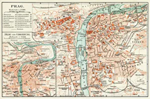
Prague map 1896Meyers Konversations-Lexikon
Scotland map 1875The Independent Course Comprehensive Geography by James Monteith, A.S. Barnes & Co, New York & Chicago 1875
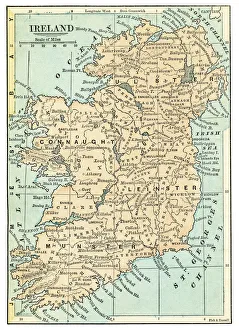
Ireland map 1875The Independent Course Comprehensive Geography by James Monteith, A.S. Barnes & Co, New York & Chicago 1875
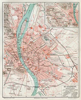
Budapest city map 1895Meyers Konversations-Lexikon. Ein Nachschlagewerk des allgemeinen Wissens, 5th edition 17 volumes Bibliographisches Institut - Leipzig 1895-1897
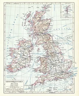
Great Britain and England map 1895Encyclopedia Britannica 9th Edition Vol I New York, Samuel Hall 1878
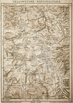
Map of Yellowstone National Park, USA
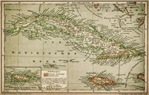
Caribbean mapAntique map of Cuba, Jamaica, Puerto Rico
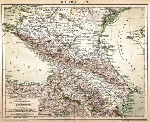
Old Caucasus mapAntique map of Caucasus
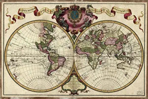
Map of the world, 1720(Original Caption) 18th century map of the world. Published in Paris in 1720, this French map shows the known world, including the new lands that had been discovered in the preceding centuries by
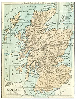
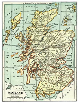
Map of Scotland 1889Comprehensive Geography by James Monteith - American Book Company 1882, 1889
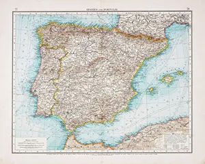
Map of Spain and Portugal 1896Andres Allgemeiner Handatlas - Bielefeld und Leipzig 1896
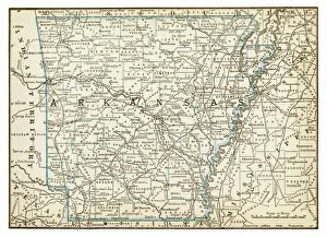
Map of Arkansas 1893New Pocket Atlas / Rand, McNally & Co -1893
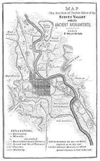
Squier Map of Hopewell Culture National Historical Park in Ross County, Ohio, USAMap of the Scioto River Valley around Chillicothe in Ross County, New York, United States of America. Map by Ephraim George Squier
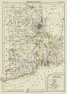
Rhode Island map 1877Warrens Common School Geography 1877
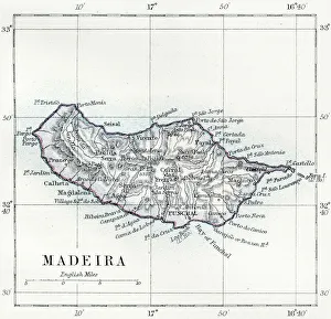
Madeira island map 1883Encyclopedia Britannica 9th Edition New York Samuel L. Hall 1883 Vol XV
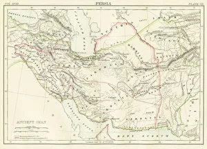
Ancient Iran map 1885Encyclopedia Britannica 9th Edition New York Charles Scribners and Sons 1885 Vol XVIII
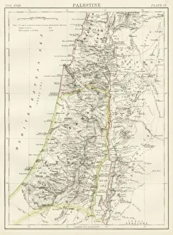
Palestine map 1885Encyclopedia Britannica 9th Edition New York Charles Scribners and Sons 1885 Vol XVIII
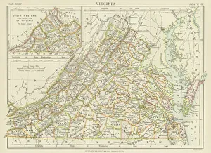
Virginia map 1885Encyclopedia Britannica 9th Edition New York Charles Scribners and Sons 1885 Vol XXIV
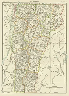
Vermont USA map 1885Encyclopedia Britannica 9th Edition New York Charles Scribners and Sons 1885 Vol XXIV
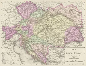
Austria Hungary map 1893Johnsonas Universal Cyclopedia - Charles Kendall - New York 1893
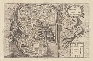
Map of the ancient Jerusalem, copperplate engraving, published in 1774Map of the ancient Jerusalem. Copperplate engraving, published in 1774
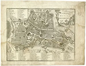
17th century city, plan of Augsburg, GermanyTypical fortifications and references. Rich in details, beautifully aged paperPublished by J. Stockdale, Piccadilly 1800
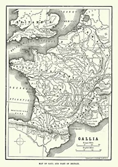
Map of Ancient Gaul (France)Vintage engraving of a Map of Ancient Gaul (France)
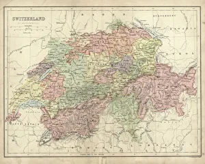
Antique map of Switzerland in the 19th Century, 1873
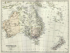
Antique map of Australia and New Zealand, 1884, 19th Century
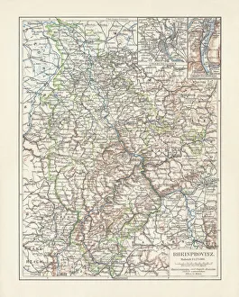
Map of Rhine Province (Prussia, Germany), lithograph, published in 1897Topographic map of Rhine Province, the westernmost province of Prussia, within the German Reich, from 1822 to 1946. Lithograph, published in 1897
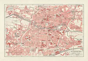
Historical city map of Nuremberg, Bavaria, Germany, lithograph, published 1897
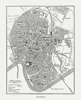
Historical city map of Krakow, Poland, wood engraving, published 1897Historical city map of Krakow, Poland. Wood engraving, published in 1897
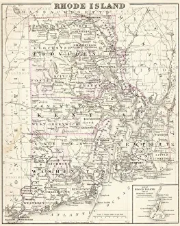
Map of Rhode island 1883Encyclopedia Britannica 9th Edition New York Samuel L. Hall 1883 Vol XX
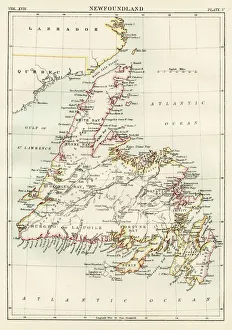
Newfoundland map 1884Encyclopedia Britannica 9th Edition New York Charles Scribners and Sonsl 1884 Vol XVII
Map of Kiel, capital of Schleswig-Holstein, Germany, lithograph, published 1887Map of Kiel and surroundings, capital and most populous city in the northern German state of Schleswig-Holstein. Lithograph, published in 1887
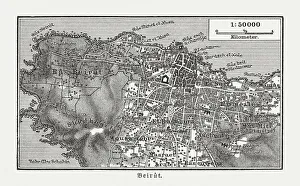
Historic city map of Beirut, Lebanon, wood engraving, published 1897Historic city map of Beirut - capital and largest city of Lebanon. Wood engraving, published in 1897
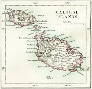
Maltese islands map 1883Encyclopedia Britannica 9th Edition New York Samuel L. Hall 1883 Vol XV
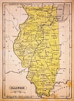
Illinois 1852 Map
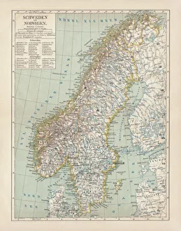
Sweden and Norway, lithograph, published in 1878Ancient map of Sweden and Norway. Lithograph, published in 1878
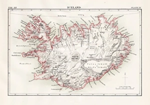
Iceland map 1881Encyclopedia Britannica 9th Edition Vol XII Philadelphia j.M. Stoddart & Co 1881
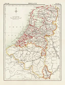
Holland map 1881Encyclopedia Britannica 9th Edition Vol XII Philadelphia j.M. Stoddart & Co 1881