mail_outline sales@mediastorehouse.com
3,671 items
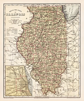
Illinois map 1881Encyclopedia Britannica 9th Edition Vol XII Philadelphia j.M. Stoddart & Co 1881
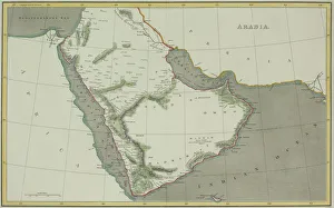
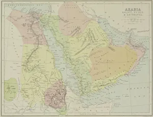
Antique map of Arabian peninsula and Persia
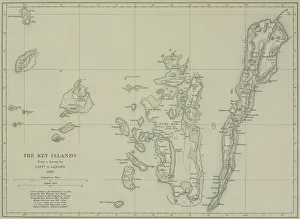
Antique map of the Key Islands
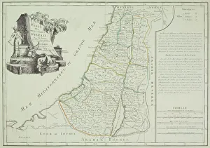
Antique map of Israel
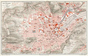
Stuttgart map 1895Meyers Konversations-Lexikon. Ein Nachschlagewerk des allgemeinen Wissens, 5th edition 17 volumes Bibliographisches Institut - Leipzig 1895-1897
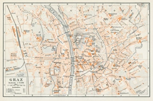
Graz Austria map 1895Encyclopedia Britannica 9th Edition Vol I New York, Samuel Hall 1878
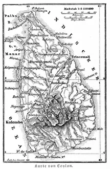
Srilanka former Ceylon map 1895Meyers Konversations-Lexikon. Ein Nachschlagewerk des allgemeinen Wissens, 5th edition 17 volumes Bibliographisches Institut - Leipzig 1895-1897
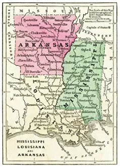
Map of USA southern states 1871Colton and Fitchs Introductory School Geography - New York: Sheldon and Company 1871
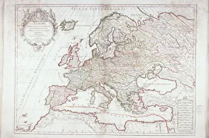
Map of EuropeAntique Maps, TR002298
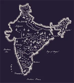
Antique India MapIndia Map, - Antique style. Includes mountains and water bodies. High detail - vector illustration
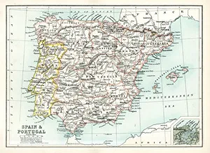
Antique map of Spain and Portugal from 1891 with a detail of Santander
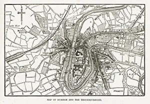
Map of the City of Durham, England Victorian Engraving, 1840Very Rare, Beautifully Illustrated Antique Engraving of Map of the City of Durham, England Victorian Engraving, 1840. Source: Original edition from my own archives
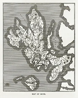
Map of the Isle of Skye, Scotland Victorian Engraving, 1840Very Rare, Beautifully Illustrated Antique Engraving of Map of the Isle of Skye, Scotland Victorian Engraving, 1840. Source: Original edition from my own archives
United States map 1881Coltons Common School Geography 1881 New York Sheldon and Co
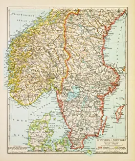
Map of Sweden and Norway 1897Map of Sweden and Norway
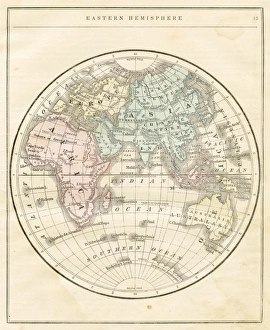
Eastern Hemisphere map 1856Colton and Fitchs Modern School Geography by George W. Fitch - New York 1856
Antique map of Arabia with Egypt, Nubia, and Abyssinia
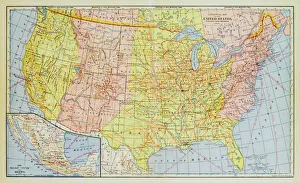
1883 United States Map
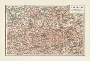
Map of Salzburg, federal state in Austria, lithograph, published 1897Map of Salzburg, federal state in Austria. Lithograph, published in 1897
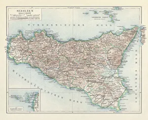
Topographic map of Sicily, Italy, lithograph, published in 1897Topographic map of Sicily, Italy - largest island in the Mediterranean Sea. Lithograph, published in 1897
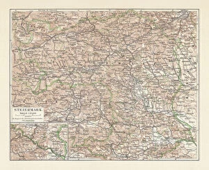
Topographic map of Styria, Austria, lithograph, published in 1897Topographic map of Styria - state (Bundesland) located in the southeast of Austria. Lithograph, published in 1897
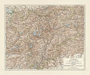
Tyrol, historical region in Austria and Italy, lithograph, published 1897Tyrol - historical region in the Alps; in northern Italy and western Austria. Lithograph, published in 1897
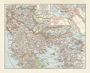
Historical map of the Ottoman Empire (Turkey), European part, 1897Historical map of European part of the Ottoman Empire (Turkey) at the end of the 19th century. Lithograph, published in 1897
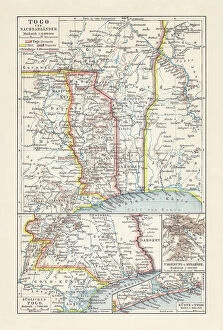
Historical map of Togo during the German colonial period (1884-1916)Historical map of Togo in West Africa during the German colonial period from 1884 to 1916. Lithograph, published in 1897
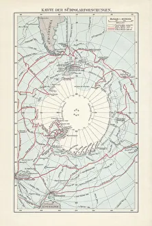
Antarctica map with sea routes of various explorers, lithograph, 1897Historical map of the unexplored Antarctica with sea routes of various explorers, 18th - 19th century. Lithograph, published in 1897
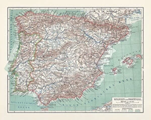
Topographic map of Spain and Portugal, lithograph, published in 1897Topographic map of Spain and Portugal. Lithograph, published in 1897
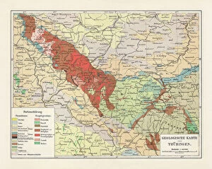
Geological map of Thuringia, Germany, lithograph, published in 1897Geological map of Thuringia, Germany. Lithograph, published in 1897
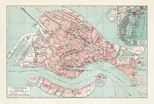
City map of Venice, Italy, lithograph, published in 1897City map of Venice, Italy. Lithograph, published in 1897
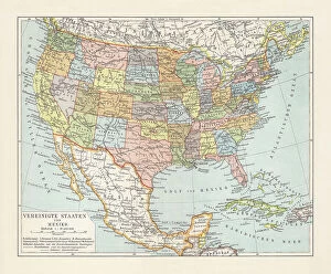
Political map of United States and Mexico, lithograph, published 1897Political map of the United States (excluding Alaska) and Mexico. Lithograph, published in 1897
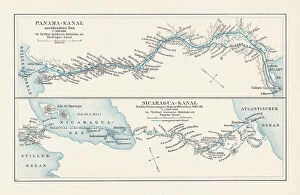
Map of projects of Panama and Nicaragua Canal, lithograph, 1897Map of the historical projects of the Panama Canal (unfinished construction) and the Nicaragua Canal (in planning). Lithograph, published in 1897
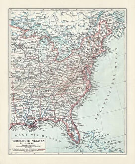
Topographical map of the United States, Eastern States, lithograph, 1897Topographical map of the United States of America, Eastern States. Lithograph, published in 1897
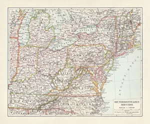
Topographic map of the Northeastern United States, lithograph, 1897Topographic map of the Northeastern United States. Lithograph, published in 1897
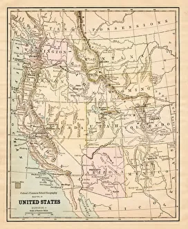
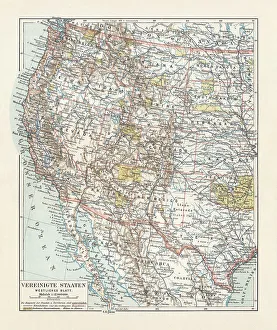
Topographic map of the United States, western states, lithograph, 1897Topographic map of the United States of America, western states with the marking (yellow) of the indian reservations. Lithograph, published in 1897
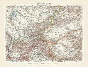
Historical topographic map of Central Asia, lithograph, published in 1897Topographic map of Central Asia with the nation borders during the British Empire. Lithograph, published in 1897
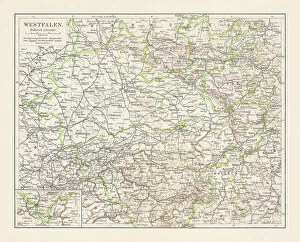
Historical map of Westphalia (North Rhine-Westphalia), Germany, lithograph, published 1897Historical map of Westphalia (today North Rhine-Westphalia), former Prussian province in the German Empire. Lithograph, published in 1897
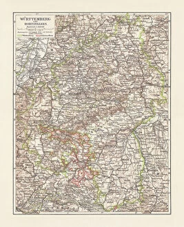
Historical map of Wurttemberg and Hohenzollern, Germany, lithograph, published 1897Historical map of Wurttemberg and the former Prussian Province of Hohenzollern (today Baden-Wurttemberg) in the German Empire. Lithograph, published in 1897
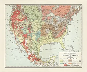
Geological map of USA and Mexico, lithograph, published in 1897Geological map of the United States of America and Mexico. Lithograph, published in 1897
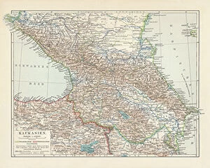
Topographic map of the Caucasus Region, lithograph, published in 1898Historical topographic map of the Caucasus Region. Lithograph, published in 1898
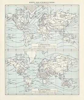
World map of the thermal extremes from 1892, lithograph, 1898World map of the thermal extremes (annual minima and annual maxima) from the year 1892. The red numbers indicate the absolute Minima (top) and Maxima (bottom). Values in degrees Celsius
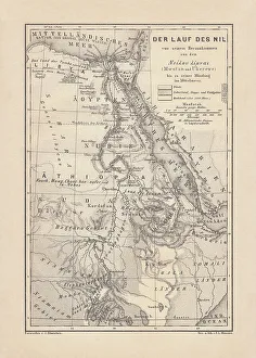
Historical map of the Nile river, wood engraving, published 1879Historical map of the course of the Nile river from the source areal to the mouth. Wood engraving, published in 1879
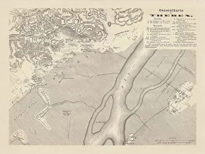
Historical map of Thebes, Egypt, wood engraving, published in 1879Historical map of Thebes, Egypt. Wood engraving, published in 1879
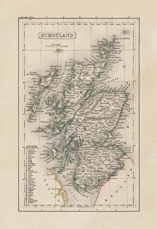
Old map of Scotland, steel engraving, published 1857Old map of Scotland. Steel engraving with hand coloured borderlines, published in 1857
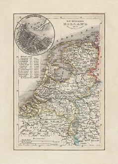
Old map of the Netherlands, steel engraving, published 1857Old map of the Netherlands and Amsterdam. Steel engraving with hand coloured borderlines, published in 1857
Old map of the European Russia, steel engraving, publishedOld map of the European Russia. Steel engraving with hand coloured borderlines, published in 1857
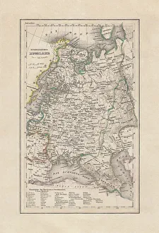
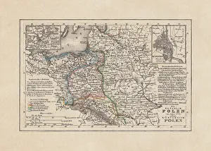
Old map of Poland, steel engraving, published in 1857Old map of the Republic and the Kingdom of Poland in 1772 with the cities of Warsaw and Vilnius. Steel engraving with hand coloured borderlines, published in 1857
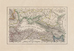
Coastal countries of the Black Sea, steel engraving, published 1857Old map of the coastal countries of the Black Sea. Steel engraving with hand coloured borderlines, published in 1857
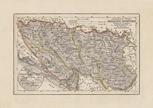
Old map of Serbia and Bosnia, steel engraving, published 1857Old map of Serbia and Bosnia. Steel engraving with hand coloured borderlines, published in 1857
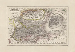
Old map of Romania and Bulgaria, steel engraving, published 1857Old map of Romania and Bulgaria. Steel engraving with hand coloured borderline, published in 1857