mail_outline sales@mediastorehouse.com
3,669 items
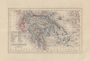
Old map of Greece, steel engraving, published 1857Old map of Greece. Steel engraving with hand coloured borderlines, published in 1857
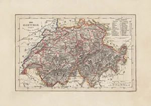
Old map of Switzerland, steel engraving, published in 1857Old map of Switzerland. Steel engraving with hand coloured borderlines, published in 1857
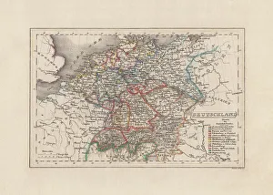
Old map of Germany, steel engraving, published in 1857Old map of Germany. Steel engraving with hand coloured borderlines, published in 1857
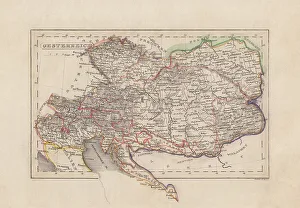
Old map of Austria (Danube monarchy), steel engraving, published 1857Old map of Austria (Danube monarchy). Steel engraving with hand coloured borderlines, published in 1857
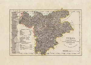
Old map of Tyrol (Austria), steel engraving, published in 1858Old map of Tyrol (Austria). Steel engraving with hand coloured borderlines, published in 1858
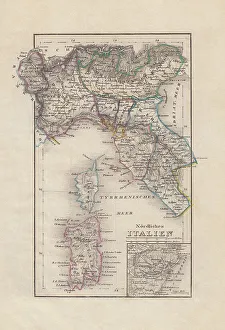
Old map of Northern Italy, steel engraving, published in 1857Old map of Northern Italy with city map of Venice. Steel engraving with hand coloured borderlines, published in 1857
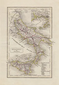
Old map of Southern Italy, steel engraving, published in 1857Old map of Southern Italy (Naples and Sicily). Steel engraving with hand coloured borderlines, published in 1857
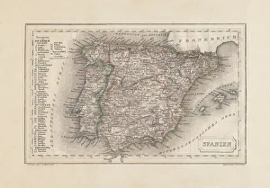
Old map of Spain and Portugal, steel engraving, published 1857Old map of Spain and Portugal. Steel engraving with hand coloured borderlines, published in 1857
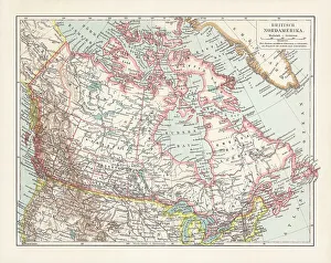
Historical map of the British North America, chromolithograph, published 1899Historical map of the British North America. It refers to the former territories of the British Empire in North America, not including the Caribbean
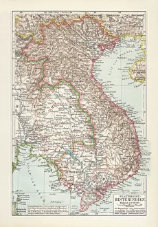
Historical map of French Indochina, chromolithograph, published in 1899Historical map of French Indochina - a grouping of French colonial territories in Southeast Asia. Chromolithograph, published in 1899
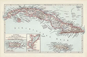
Map of Cuba, Jamaica, and Puerto Rico, chromolithograph, published 1899Historical map of the caribbean islands Cuba, Jamaica, and Puerto Rico. Chromolithograph, published in 1899
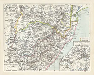
Map of South Africa during the Second Boer War, 1899-1902Topographic map of South Africa during the Second Anglo Boer War (11 October 1899 - 31 May 1902). Lithograph, published in 1900
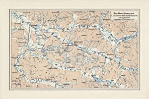
River system of Brandenburg and Saxony Anhalt, Germany, lithograph, 1900Old map of the river system of areas in Brandenburg and Saxony Anhalt, Germany. Lithograph, published in 1900
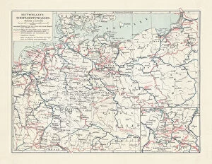
Inland waterway map of the German Empire, lithograph, published 1900Historical inland waterway map of the German Empire. Lithograph, published in 1900
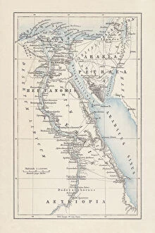
Map of Egypt during the Roman Empire, lithograph, published 1893Map of ancient Egypt during the Roman Empire. Lithograph, published in 1893
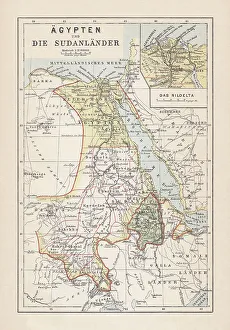
Map of Egypt, Nile Delta and Sudan, lithograph, published 1893Historical map of Egypt, Nile Delta and Sudan. Description in German. Lithograph, published in 1893
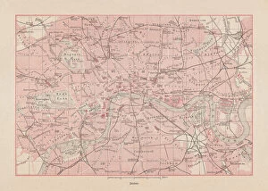
Historical city map of London, England, lithograph, published 1893Historical city map of London - capital and largest city of England and the United Kingdom. Lithograph, published in 1893
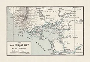
Historical map of Cameroon, lithograph, published in 1893Historical map of Cameroon during the German colonization in the late 19th century. Lithograph, published in 1893
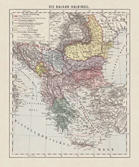
Map of the Balkan Peninsula, late 19th century, lithograph, 1893Historical map of the Balkan Peninsula, late 19th century. Explanations in German. Lithograph, published in 1893
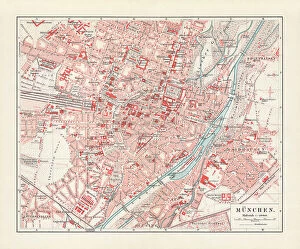
Historical city map of Munich, Bavaria, Germany, lithograph published 1897Historical city map of Munich, Bavaria, Germany. Lithograph, published in 1897
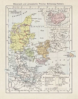
Map of Denmark, Iceland, Faroe Islands and Schleswig-Holstein. lithograph, 1893Historical map of Denmark with Iceland, the Faroe Islands and the Prussian province of Schleswig-Holstein. Lithograph, published in 1893
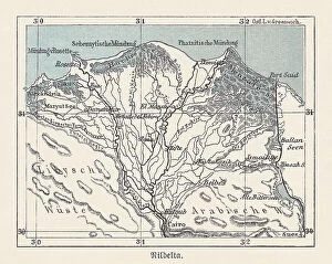
Historical map of the Nile Delta, Egypt, lithograph, published 1893Historical map of the Nile Delta in Egypt - one of the world's largest river deltas - from Alexandria in the west to Port Said in the east, it covers 240 km (150 mi) of Mediterranean coastline
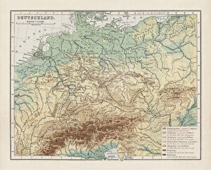
Topographic map of Germany, lithograph, published in 1893Topographic map of Germany and former territories. Lithograph, published in 1893
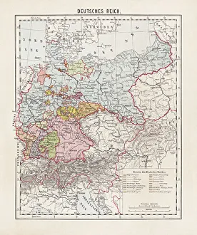
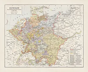
States of the German Empire, lithograph, published in 1893Map of the states of the German Empire at the end of the 19th century. Lithograph, published in 1893
Map of Germany in 1789, lithograph, published in 1893Map of Germany with the individual states at the outbreak of the French Revolution in 1789. Lithograph, published in 1893
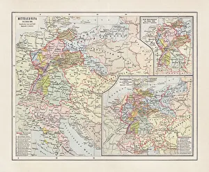
Map of Central Europe in 1811, lithograph, published in 1893Map of Central Europe in 1811. Lithograph, published in 1893
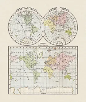
World map. Western and Eastern hemispheres, lithograph, published in 1893World map. Western and Eastern hemispheres. Descriptions in German. Lithograph, published in 1893
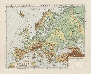
Physical map ofl Europe, lithograph, published in 1893Physical map of Europe. Descriptions in German. Lithograph, published in 1893
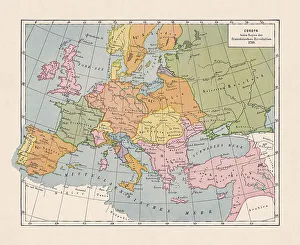
Map of Europe in 1789 (French Revolution), chromolithograph, published 1900Historical map of Europe in 1789, beginning of the French Revolution. Designations in German. Chromolithograph, published in 1900
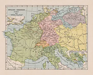
Map of the Napoleonic Empire in 1812, chromolithograph, published 1900Historical map of the Napoleonic Empire in 1812. map of the Napoleonic Empire in 1812. Chromolithograph, published in 1900
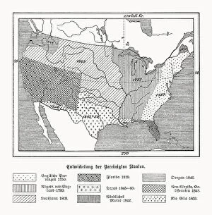
Historical development of the USA, wood engraving, published in 1899Map of the historical development of the United States of America during the 18th and 19th centuries (explanations in German). Left: English provinces 1750; Dismissed by England 1783; Louisiana 1803
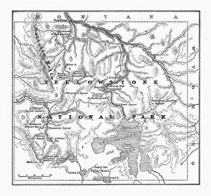
Map of Yellowstone National Park, USA, wood engraving, published 1899Historical map of Yellowstone National Park in the USA. It was founded on March 1, 1872, making it the oldest national park in the world. In 1978 UNESCO declared it a World Natural Site
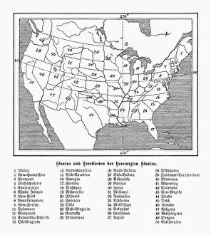
States and territories of the USA, wood engraving, published 1899Historical map of the states and territories of the United States of America (excluding Alaska and Hawaii). Explanations in German. Wood engraving, published in 1899
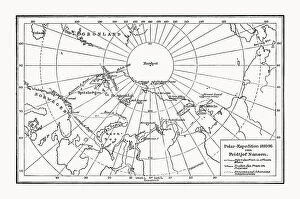
Polar expedition by Fridtjof Nansen, wood engraving, published in 1899Map of the polar expedition 1893-96 by Fridtjof Nansen (Norwegian polymath, 1861 - 1930). Explanations in German. Wood engraving, published in 1899
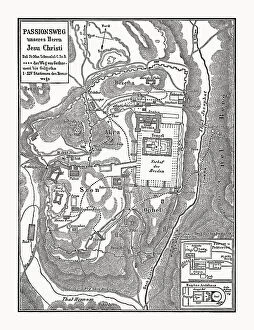
Map of the Stations of the Cross of Jesus ChristHistorical map of Jerusalem with the Stations of the Cross of Jesus Christ. From Gethsemane to Calvary. Explanations in German. Wood engraving, published in 1898
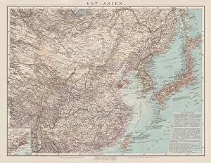
Map of China, Japan and Korea, chromolithograph, published in 1900Historical map of East Asia with China, Japan and Korea. Explanations in German. Chromolithograph, published in 1900
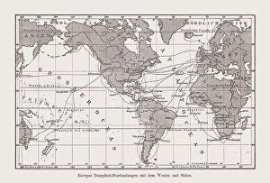
Historical map of Europe's steamship connections, wood engraving, published 1894Historical map of Europe's steamship connections to the west and south at the end of the 19th century. Description in German language. Wood engraving, published in 1894
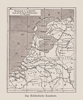
Map of the Dutch waterway network, wood engraving, published 1894Historical map of the Dutch waterway network. Description in German language. Wood engraving, published in 1894
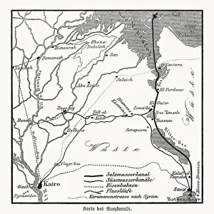
Map of the Suez Canal, Egypt, wood engraving, published in 1869Historical map of the Suez Canal - an artificial sea-level waterway in Egypt, connecting the Mediterranean Sea to the Red Sea through the Isthmus of Suez and dividing Africa and Asia
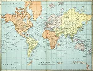
Old map of the World Map, Published 1894Antique Illustration. Copyright has expired on this artwork. From my own archives, digitally restored
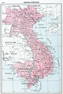
Antique map of Vietnam, Laos, Cambodia and Ta'hailandAntique map of Vietnam, Laos, Cambodia and TÔǽhailand
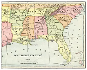
Map of USA southern states 1897Natural Elementary Geography by Redway and Hinman - NY/Cincinnati/Chicago 1897
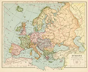
Map of Europe 1899Maurys Geographical Series Manual of Geography - New York 1899
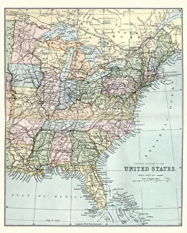
Map of the Eastern United States of America, 19th CenturyVintage engraving of a Map of the Eastern United States of America, late 19th Century
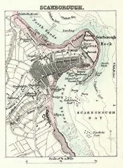
Map of Scarborough" Vintage map from 1880 of Scarborough, a town on the North Sea coast of North Yorkshire, England.++Inspector: Info about source material uploaded as property release++"
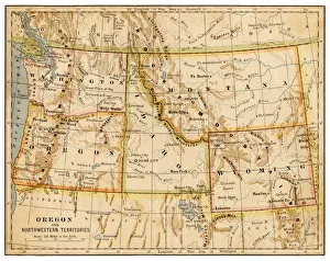
Map of Oregon and northwestern territories 1883The Eclectic Elementary Geography by Van Antwerp, Bragg & C0 / Cincinnati -New York 1883
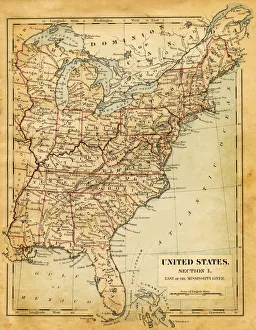
Map of USA - East of Mississippi river 1876Maurys Geographical Series - The Word we live in by M.F. Maury LLD - New York and Baltimore 1876
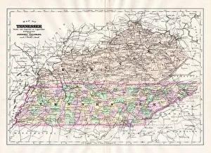
Map of Tennessee 1894Johnsons Universal Cyclopedia - Volume VIII New York - A. J. Johnson Company 1894