Home > Photo Libraries > The Illustrated London News (ILN)
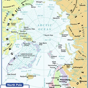
Victorian map of the Arctic Circle

![]()
Wall Art and Photo Gifts from Fine Art Storehouse
Victorian map of the Arctic Circle
A Victorian map of the Arctic Circle and beyond. From Peter Parleyas Annual - A Christmas and New Yearas Present for Young Peoplea published in London by Darton & Co in 1851
Linda Steward
Media ID 13667237
© Linda Steward
62990 78279 Arctic Atlantic Ocean Circle Continent Country Geographic Area Direction Directly Above Earth Education Empire Globe Navigational Equipment Latitude Line Art Longitude Memories Monochrome Navigational Equipment North America Nostalgia Pacific Ocean Sepia Toned Social History The Americas
FEATURES IN THESE COLLECTIONS
> Map
> Historical Maps
> Map
> Photo Libraries
> The Illustrated London News (ILN)
MADE IN THE UK
Safe Shipping with 30 Day Money Back Guarantee
FREE PERSONALISATION*
We are proud to offer a range of customisation features including Personalised Captions, Color Filters and Picture Zoom Tools
SECURE PAYMENTS
We happily accept a wide range of payment options so you can pay for the things you need in the way that is most convenient for you
* Options may vary by product and licensing agreement. Zoomed Pictures can be adjusted in the Basket.