Framed Print > Map > Italian Maps
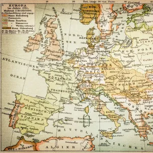
Framed Print : Antique Map of Europe, 1785


![]()
Framed Photos from Fine Art Storehouse
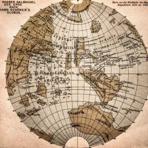
Antique Map of Europe, 1785
An accurate map of Europe from the best authorities. London: C. Dilly & G. Robinson: 1785. Original size: 35.7 x 37.4 cm. Coloured, Inset: Spitsbergen, East and West Greenland, and Iceland. Engraved for William Guthrie
BernardAllum
Media ID 13597639
© Bernard Allum
Backgrounds Baltic Countries Black Sea Continent Denmark Direction Document European Culture Finland Grunge Grunge Image Technique Hungary Latitude Longitude Manuscript Ornate Paper Past Pattern Sepia Toned Social History Square Stained Textured Effect Topography Torn Travel Backgrounds Travel Locations Turkey Turkey Middle East Vector World Map
12"x10" Modern Frame
10x8 Print in an MDF Wooden Frame with 180 gsm Satin Finish Paper. Glazed using shatter proof thin plexi glass. Frame thickness is 1 inch and depth 0.75 inch. Fluted cardboard backing held with clips. Supplied ready to hang with sawtooth hanger and rubber bumpers. Spot clean with a damp cloth. Packaged foam wrapped in a card.
Contemporary Framed and Mounted Prints - Professionally Made and Ready to Hang
Estimated Image Size (if not cropped) is 25.4cm x 25.4cm (10" x 10")
Estimated Product Size is 30.5cm x 25.4cm (12" x 10")
These are individually made so all sizes are approximate
Artwork printed orientated as per the preview above, with landscape (horizontal) or portrait (vertical) orientation to match the source image.
FEATURES IN THESE COLLECTIONS
> Map
> Denmark Maps
> Map
> Historical Maps
> Map
> Italian Maps
> Map
MADE IN THE USA
Safe Shipping with 30 Day Money Back Guarantee
FREE PERSONALISATION*
We are proud to offer a range of customisation features including Personalised Captions, Color Filters and Picture Zoom Tools
SECURE PAYMENTS
We happily accept a wide range of payment options so you can pay for the things you need in the way that is most convenient for you
* Options may vary by product and licensing agreement. Zoomed Pictures can be adjusted in the Cart.