Photographic Print > Map > Historical Maps
Photographic Print : Vintage Map of the World

![]()
Photo Prints from Fine Art Storehouse
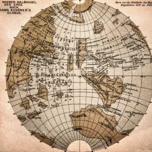
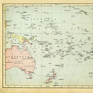
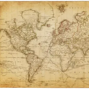
Vintage Map of the World
Vintage map of the world from 1837
duncan1890
Media ID 13666637
© duncan1890
1830 1839 1830s Style Asia Pac Atlantic Ocean Australasia Australia Cartographer Chart Discovery Dome Earth East Africa Ephemera Equipment Geographical Locations Globe Globe Navigational Equipment Hemisphere Illustrations And Vector Art Image Created 1830 1839 India Indian Subcontinent Major Ocean Manufactured Object Navigational Equipment North Africa Northern Hemisphere Objects Equipment Oceania Pacific Ocean Past Planet Planet Earth Planet Space Printed Media Retro Revival Southern Africa Southern Hemisphere Sphere The Americas Travel Locations West Africa World Map
11"x8.5" Photo Print
Photo prints are produced on Kodak professional photo paper resulting in timeless and breath-taking prints which are also ideal for framing. The colors produced are rich and vivid, with accurate blacks and pristine whites, resulting in prints that are truly timeless and magnificent. Whether you're looking to display your prints in your home, office, or gallery, our range of photographic prints are sure to impress. Dimensions refers to the size of the paper in inches.
Our Photo Prints are in a large range of sizes and are printed on Archival Quality Paper for excellent colour reproduction and longevity. They are ideal for framing (our Framed Prints use these) at a reasonable cost. Alternatives include cheaper Poster Prints and higher quality Fine Art Paper, the choice of which is largely dependant on your budget.
Estimated Image Size (if not cropped) is 27.9cm x 15.7cm (11" x 6.2")
Estimated Product Size is 27.9cm x 21.6cm (11" x 8.5")
These are individually made so all sizes are approximate
Artwork printed orientated as per the preview above, with landscape (horizontal) orientation to match the source image.
FEATURES IN THESE COLLECTIONS
> Map
> Historical Maps
> Map
MADE IN THE USA
Safe Shipping with 30 Day Money Back Guarantee
FREE PERSONALISATION*
We are proud to offer a range of customisation features including Personalised Captions, Color Filters and Picture Zoom Tools
SECURE PAYMENTS
We happily accept a wide range of payment options so you can pay for the things you need in the way that is most convenient for you
* Options may vary by product and licensing agreement. Zoomed Pictures can be adjusted in the Cart.